
The Worcester waterman’s story cannot be told as a smaller version of the Chesapeake oyster story. The county faced east as well as west. Snow Hill and Pocomoke country belonged to a tidal river system; Sinepuxent, Isle of Wight, Newport, and Chincoteague bays formed a protected but constantly changing lagoon behind the barrier islands; and the Atlantic offered an entirely different fishery, with surf launches, fixed pound nets, and later charter boats running through Ocean City Inlet.
Yet the most basic lesson was the same everywhere: children learned water by being on it. A boy in a skiff on a quiet creek and a commercial crew working a pound net miles offshore were separated by scale, equipment, and danger, but both depended on knowing what water did in a particular place.
The First Water People
Before Worcester County was created in 1742, the Pocomoke and Assateague peoples lived in a landscape organized around waterways. The Pocomoke country extended through the lower Eastern Shore, while Assateague communities occupied the coastal side of what became Worcester and Wicomico counties. Fishing, shellfish gathering, hunting, farming, and travel were connected through rivers and bays rather than separated into modern recreational and commercial categories.
Across the Indigenous Chesapeake, dugout canoes served as fishing boats and transportation. Nets could be made from plant-fiber cordage, and fishing was practiced at a scale sufficient to supply settled communities. The English did not introduce Worcester’s people to the idea that water could be a highway and food source; they entered a region where that knowledge was already ancient.
Two Water Worlds in One County
| Water | Typical opportunities | Skills emphasized |
|---|---|---|
| Pocomoke River and tributaries | Shad, herring/alewives, perch, catfish, eels, other river fish; transport to Snow Hill | Current, fish runs, nets, narrow channels, landings |
| Coastal bays | Oysters, clams, crabs, finfish, turtles; protected-water transport | Tide, shoals, marsh guts, shallow draft, changing inlets |
| Atlantic Ocean | Large commercial finfish catches, pound nets, later charter and sport fisheries | Surf launches, offshore weather, fixed gear, ocean navigation |
A Worcester fisherman could spend his entire life in one of these environments, but the county economy connected them. Fish landed on the beach could move by horse cart and railroad. Bay seafood fed hotels. River landings supplied towns. The resort that became Ocean City grew partly because fishermen and visitors were already drawn to the shore.
For the Family Table: The Fishing Nobody Counted
Commercial statistics tell us how many pounds or fish were sold. They tell us almost nothing about the perch brought home in a bucket, crabs dipped from a bank, turtles trapped in a marsh, clams gathered for a meal, or boys who took a skiff out because there was finally enough water in the creek after lunch.
That personal harvest mattered. In a rural household, fish and shellfish could add protein without a cash purchase. The outing could be useful and enjoyable at once. An older child learned to row or pole, bait a line, set a small net, clean fish, and judge weather. The regional Eastern Shore practice called turkling —turtle trapping—belongs to this same unofficial education. None of it required a business license to teach a child the marsh.
Shad on the Pocomoke
The Pocomoke River supported one of Worcester’s most important documented finfish fisheries. A federal survey of the 1896 season found commercial gear from the lower river to Snow Hill. Twenty-one drift-net boats worked from Shelltown and Rehobeth toward the lower river and near Snow Hill, generally with two men aboard. Those boats took 1,293 roe shad and 1,905 buck shad.
Other fishermen used seines and fyke nets. Six seines worked at Cedar Hall, near Nassawango Creek, and at McKee Island above Snow Hill; those nets also brought in alewives, perch, and catfish. Fyke nets set by people around Rehobeth and Shelltown caught eels, perch, alewives, catfish, pike, and incidental shad. The range of gear is a reminder that “fishing” was never one technique.
The work was seasonal. A fisherman could not make spring shad run in August simply because he needed money. He had to fit his labor to migration, water temperature, current, and market. That need to change work with the calendar was one of the defining features of waterman life.
Behind Assateague: Oysters, Clams, Crabs, and Fish
Worcester’s coastal bays were shallow, salty, and strongly affected by whether an inlet was open to the ocean. Residents harvested oysters and clams, crabbed, netted fish, and used marsh resources for home and market. The productivity of those fisheries shifted as inlets opened, shoaled, and closed. By the early twentieth century, state officials were already discussing how improved exchange with the Atlantic might revive shellfish resources in Sinepuxent and Chincoteague bays.
The shallow bays favored skiffs, catboats, and other light-draft craft. They also created a childhood water world radically different from the open Atlantic only a strip of sand away. A boy could crab or fish in protected water while older men worked gear offshore. Both learned tide, but one could usually retreat into a creek; the other might have to launch a loaded dory through breaking surf.
The Ocean Pound-Fishing Era
In the 1890s a new commercial fishery came to the ocean beach. Christopher Ludlam and his family, experienced pound fishermen from Cape May, New Jersey, introduced large fixed pound nets off Ocean City in about 1896–97. Hickory poles were driven into the ocean bottom and heavy netting formed a leader and holding pounds that intercepted migrating fish.
The work was industrial in scale but astonishingly physical. Crews went offshore in open boats, lifted and emptied the nets, sorted the catch, and brought fish to the beach. Horses helped haul boats through the surf and moved baskets of fish toward the railroad. The catch could then travel north packed in ice rather than remaining a purely local food.
Local entrepreneurs joined the industry. Former Life-Saving Service surfman Edwin Z. Purnell became associated with the Atlantic Fish Company with Turner Cropper , William Gibbs , Charles A. Parker , William H. Parker , and Riley N. Quillen . Other fishing camps and companies carried names such as Ludlam, Hagan, Quillin, Davis, Lynch, Munford, Thomas, Elliott, Belrose, and Worcester. Pound fishing briefly made the barrier beach a string of working camps rather than an empty strip of sand.
Life in the Fish Camps
At the height of the pound-fishing era, several camps operated on what is now Assateague, collectively employing large crews. Men slept and ate at the camps because the gear, weather, and dawn work made a daily commute impractical. Accounts of the Cropper brothers’ camp describe bunking and meals as part of the employment arrangement.
The industry also crossed into Ocean City’s growing resort economy. Town history remembers that while men fished, wives and mothers played important roles operating hotels and boarding establishments for visitors. Commercial fishing and tourism did not begin as separate worlds. The same household could have men hauling fish through the surf while women earned money from people who had come to the beach partly because fishing and the sea were attractions.
Watermen Living on Assateague
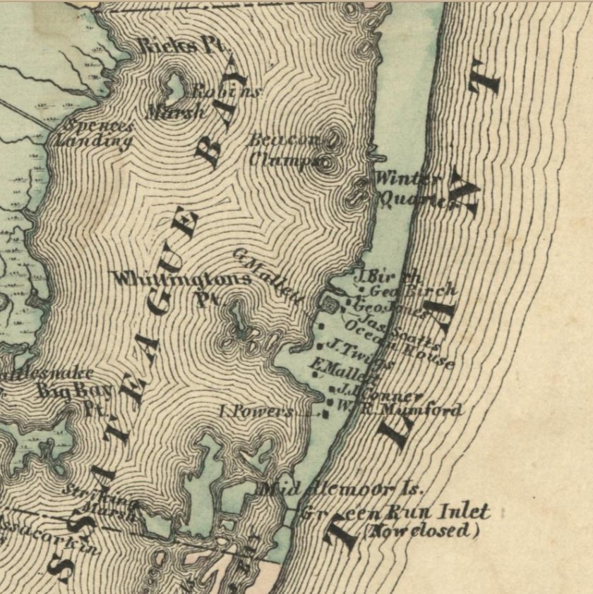
Farther south, small Assateague communities made their living from a mixture of water work, Life-Saving Service employment, trapping, gardening, and seasonal labor. At Green Run , the 1877 atlas showed about ten families, and later recollections described most residents as watermen or surfmen. James “Captain Jimmy” Scott operated the Ocean House, where fish, crabs, and oysters were specialties; Capt. Frederick Conner ’s sailing sloop Fairfield carried guests across the bay.
The island household was not sustained by fish alone. Gardens, chickens, hogs, trapping, and other work filled gaps. That is exactly why the word “waterman” should not be allowed to flatten a life. A man could fish, serve as a surfman, trap muskrats, garden, ferry people, repair boats, and still be remembered principally for his relationship with the water.
Boats for River, Bay, and Surf
Worcester had no single iconic workboat because no single boat suited all three environments. The Pocomoke used rowboats, skiffs, net boats, and larger vessels for commerce. The coastal bays favored shallow-draft skiffs and catboats. Pound fishermen used sturdy open dories or surf boats that could be launched from the beach and carried gear offshore. Engines gradually transformed all of them.
The 1933 inlet encouraged another kind of boat: the ocean charter boat. Once boats could reach the Atlantic through a protected inlet rather than being launched through surf, recreational and charter fishing became a serious Ocean City business. Captains still worked the water for money, but now the commodity could be an experience rather than a basket of fish sold wholesale.
Storms, Accidents, and the Price of Familiarity
Worcester’s coast could change in a single storm. A violent storm opened Sandy Point Inlet south of present Ocean City in 1920; light-draft fish-pound dories used the temporary passage until shoaling and later weather closed it. Storms could destroy camps, shift channels, strand boats, and turn a familiar route into an unfamiliar one overnight.
Even protected-water travel could be fatal. In 1874, sixteen-year-old Emma F. Truitt , daughter of Captain Scott and wife of Jesse J. Truitt , was traveling from the mainland in her husband’s catboat when an abrupt wind shift swung the jibboom and knocked her overboard. Her surviving stone at Green Run Inlet Cemetery preserves one life lost not in a dramatic ocean wreck but during ordinary local travel.
The presence of Life-Saving Service stations at Green Run, North Beach, and elsewhere on Assateague was itself evidence of danger. Their surfmen watched a coast where vessels routinely stranded. Many watermen lived beside those rescuers, and some men moved between fishing and lifesaving work.
1933: A Storm Creates a New Fishing Port
In August 1933 a severe storm cut a permanent inlet through the barrier island at Ocean City. Local leaders quickly recognized its value and worked to have the channel stabilized. The opening altered currents and salinity in the coastal bays, changed navigation, and gave Ocean City dependable access to the Atlantic.
It also accelerated the transition from the old pound-fishing beach economy to charter and sport fishing. Ocean City town history notes that fishermen no longer had to launch through the surf or remain confined to the bay. In 1934 the first celebrated white marlin catch helped create the identity Ocean City would later market as the “White Marlin Capital.”
Commercial fishing did not disappear, but Worcester’s public image changed. The working fisherman remained; beside him appeared the charter captain whose customers paid to fish.
Commercial Fishing, Personal Fishing, and a Changing Coast
By the mid-twentieth century, commercial and recreational fishing increasingly competed for some of the same fish, water, access, and regulation. Better roads brought more anglers. Motors, radios, synthetic line, improved ice, and later electronics changed how people found fish and how far they could travel. Ocean City grew into a resort whose fishing culture was simultaneously commercial, recreational, and promotional.
But personal fishing never vanished beneath the larger industries. A family could still catch perch in the Pocomoke, crab in a bay, dig clams where permitted, or take a small boat into a creek. The economic meaning was different from the nineteenth-century household, but the act of learning local water remained remarkably familiar.
That is Worcester’s distinctive contribution to the three-county story. Here, a child could grow up knowing a blackwater river, a salt marsh, and an ocean beach within a short distance of one another. The best watermen knew not simply “the water,” but which water they were on—and how quickly it could change.
Sources and Further Reading
- National Park Service, “Life in the Indigenous Chesapeake” .
- Maryland State Archives, Native Americans in Maryland , including Pocomoke and Assateague background.
- U.S. Commission of Fish and Fisheries, historical survey of Atlantic Coast shad fisheries , including detailed 1896 Pocomoke River gear and catch.
- Jim Casey, “A Short History of Commercial Fishing in the Chesapeake Region,” Maryland DNR .
- Ocean City Museum Society, Ocean City Then & Now, Lot 49 , for Atlantic Fish Company and pound-fishing history.
- Maryland Coastal Bays Program, “Voices of the Coastal Bays” , for pound-net methods, fish camps, and oral-history material.
- Town of Ocean City historical overview , for the Ludlam pound-fishing era, family hotel work, and the transition after the 1933 inlet.
- Maryland State Archives, Worcester County historical chronology .
- Worcester County MDGenWeb, “Assateague Island: A Historical Overview” , adapted from Edwin C. Bearss’s National Park Service study, for Green Run, island communities, inlets, life-saving stations, and Emma Truitt.