
Chapter One: Before We Start
It is appropriate before starting our story of the lands on the lower Wiccocomico AKA Rockawalkin River, to mention the reasons for occupying this place called the Calvert’s Eastern Shore. The western shore had been inhabited as early as 1634, with colonist actually living with Native Americans know as the Yaocomico, a branch of the Piscataway people. It is apparent that the settlers of the colony of Maryland chose the site on the St. Mary’s River because it was cleared land. The Indians were living in long houses and wigwams, and had crops growing in their fields.
It would be about 28 years later before Old Somerset County was formed by the Colonial Government in August of 1666. Land Surveys, Warrants and Patents were taking place in the area west of the Pocomoke River as early as 1662. Lands on the Seaboard side were not issued until about 1666. Somerset County Judicial records indicate that people from the western shore of Maryland and Virginia were trading with the Indians here as early as 1620. As a historian this brings me to the conclusion that, traders in furs as well as Indian corn, were regularly visiting what is now Somerset and Wicomico Counties of Maryland.
The word was out that the native settlements were ready for the taking, just for shillings Sterling for rent. If you transported other individuals with you, you could receive 50 more acres of land for each settler for your troubles. Some of the early patents were 500, 1000 and 2500 acres, with many of them bordered by the actual shoreline of the river of the Eastern Shore. Many of these patentees were already wealth, well-educated individuals that would later be involved in the local government, and some in Indian affairs.
Our focus in this narrative takes place on the south side of the River above mentioned, in a place called Hungary Neck, today known as Mt. Vernon in Somerset County, Maryland.
This research started as several of us later to be mentioned, were looking for the birth place of Samuel Chase one of the signers of the Declaration of Independence, which had already been study for many years. Low and behold we found ourselves on the banks of the Wicomico River at a cemetery some of us had visited in 1994. The Maryland Dept. of Transportation historic road sign marking the birth place of this Patriot, had already been move twice and now was located were we were about visit.
Our hope was to locate the cemetery of the Walker family being the ancestors of Mr. Chase, only to find the tombstones of the Waters, and Stone families. Ok now we were all scratching our heads. Cemeteries in this area for many years have been a mystery to our graveyard hunters, which included Mr. Edward M. Smith, Mr. Freddy Howard and Mr. Brice Stump.
So as we left that day in early April of 2026, we had more questions than answers. We knew more research was necessary to learn more about this land that had apparently been home for many families of Old Somerset County, Maryland. So here we go.
Chapter Two: The First Settlers
As previously mentioned the first grants of land were very large and many of the boundaries were the rivers and creeks that issued out of those waterways. Two 1000 acres tracts are important to the rest of this story. The first issued to David Spence in 1663 called The Dispence, and the second one issued to William Thomas of the Colony of Virginia called The Lott.
Somerset County Deed Liber M 4 folio 233, 1675 (which explains the title to these lands) follows and creates a base for the title, and history of many colonial families of Old Somerset County, Maryland .
This Indenture made the Fifth day of June in the year of the dominion of the right honorable Cecilus Absolute Lord and Proprietor of the Province of Maryland and Avalon Lord Barron of Baltimore and in the year of our Lord one thousand six hundred seventy & five. (1675) Between Thomas Roe of Somerset County in the province of Maryland a planter and Anne his wife of the one part and Thomas Walker Sr. of the County and Provence aforesaid, Gentleman of the other part. Witnessed that the said Lord Baltimore by his deed of grant under the Great Seal within the said Province of Maryland for granting land, thence bearing the date at St. Mary’s the eighth day of February 1663 and for the consideration mentioned granted to David Spence. A parcel of land called The Dispence situated and lying and being on the Wiccocomico River on the Eastern Shore of Maryland, on the southernmost side of the said river. Beginning at the mouth of a little creek called Deceels Creek and running up the river, and with several courses within the survey returning to the above mentioned Deceels Creek, containing one thousand acres of Land.
(See the overlay and plat below for more information on the actual survey) “David Spence according to Clayton Torrance in his book Old Somerset, states that Spence lived on his tract of land on the Wiccocomico River”. David Spence was the constable for Wicomico Hundred, and listed as one of the first settlers of the new County. He received 50 Acres of land for transporting himself, James Dashiell and Ann his wife, and seven others in to the colony to settle. “According to some secondary sources David Spence was a Scottish immigrant born in Dysart, Fife, Scotland around 1639 to John de Spence, arriving around 1663. He died at the age of 40 in Somerset County in 1679”.
The following pages in this document are intended to explain the title chain of this tract of land, finally sold equally to Thomas Roe to Thomas Walker Sr. in Deed Liber M 4 Somerset Co. records.
Writer’s Note: The name of the Creek mentioned in this deed of grant to sub-divide the one thousand acres was the southern boundary of tract called The Dispense. The spelling of the creek name Deceels is apparently an early spelling of Dashiell, the colonial family. I was unable to discover any other explanation.
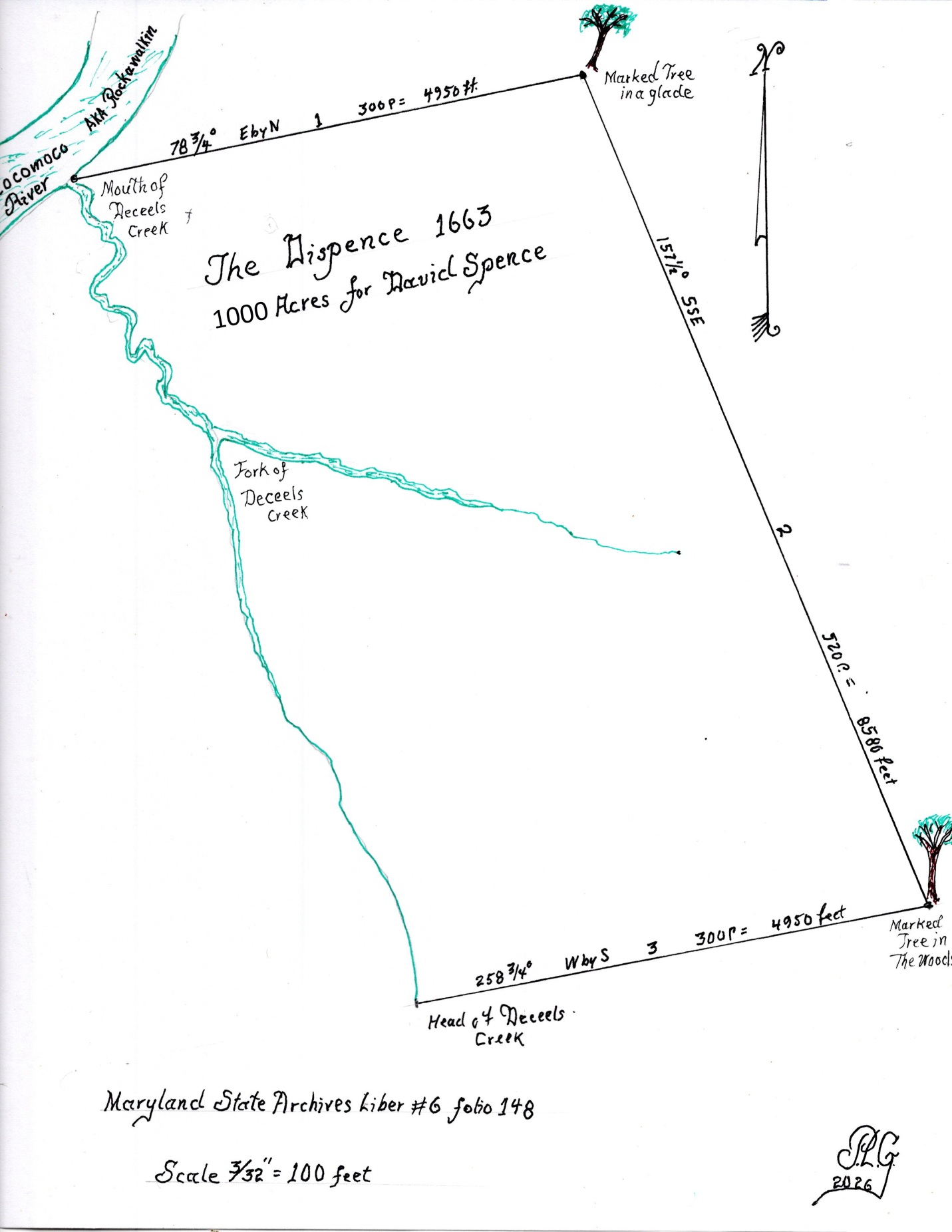
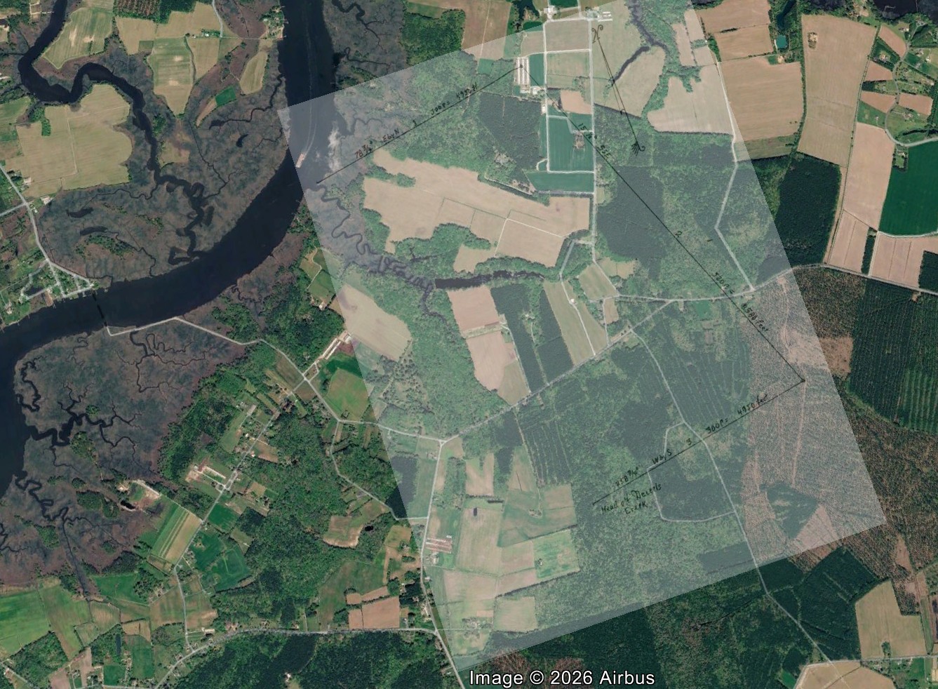
On the next page is a plat drawn by the Author based on the meets and bounds recited in the certificate of survey for David Spence. No plat was found in records at the Maryland State Archives, or Somerset County Plats. The Harry Benson maps indicate the outlines of the patent in his maps, but without courses and distances.
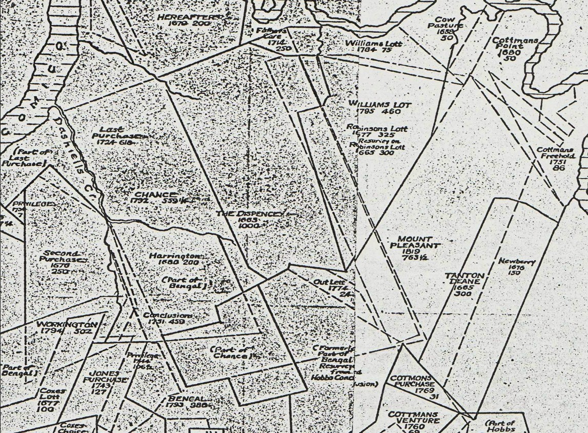
Mr. Harry L. Benson’s map shows how many later patents overlay earlier plats in the 17th & 18th century, such as Last Purchase of William Walker Jr. 1724 and Chance of Capt. Thomas Waters in 1792.
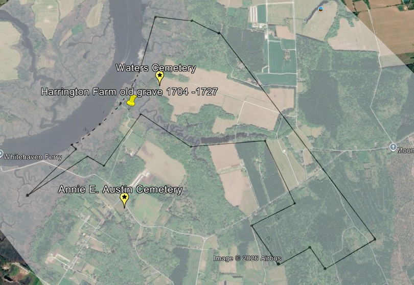
The Google Earth overlay below indicates the lines of the tract called The Dispence as it relates to the ground today near the Whitehaven area and the lower ferry. The southern boundary is Stone Creek in modern times, AKA Deceels or Dashiell Creek in colonial times.
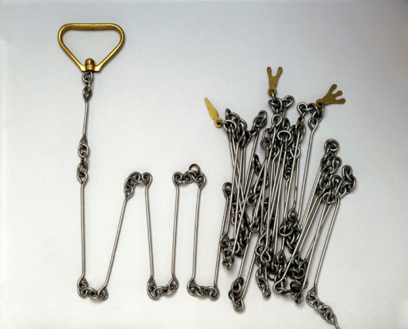
Please note that the southern boundary of the tract is not shown by a drawn line in the image. Stone Creek aka Dashiell Creek runs south to a fork. The boundary in this survey uses the south branch of the creek running south well into the forest until it intersects with the 3rd line of the survey. The reason for this situation is the fact that running the lines by magnetic compass and Gunter Chain along a meandering creek would have been very difficult in the colonial times.
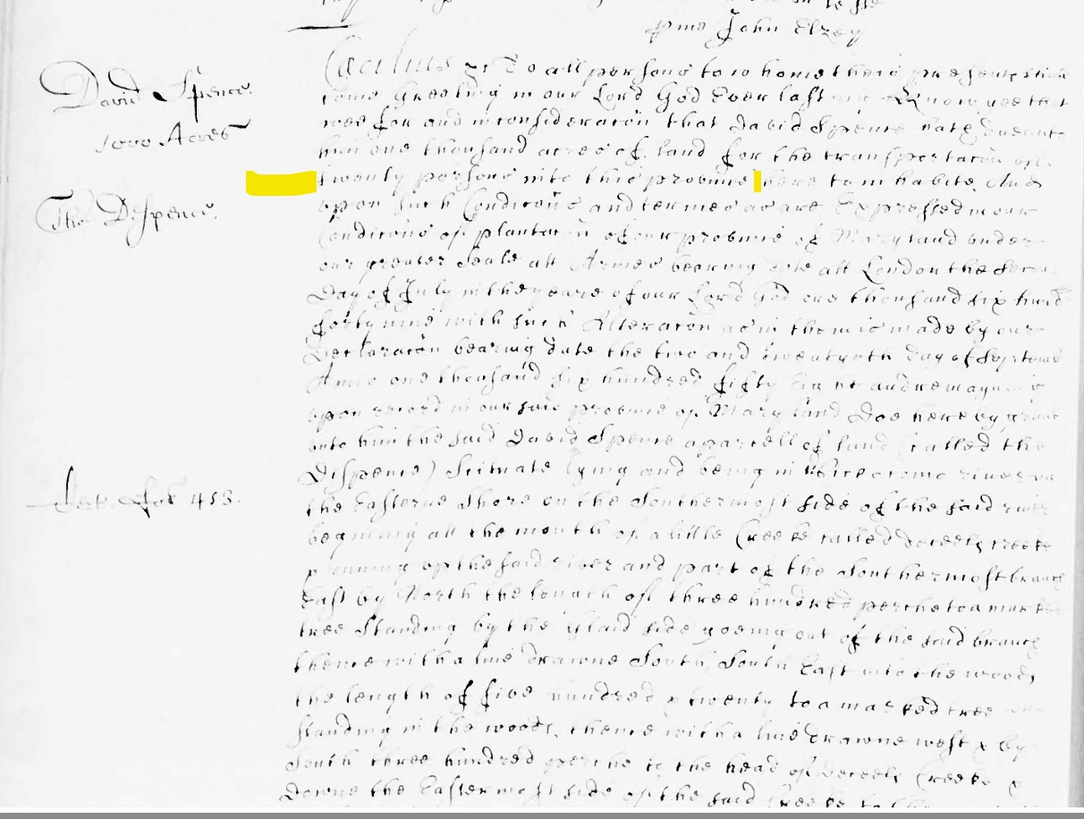
On the following page is a partial copy of an early transcript of the original patent issued to David Spence recorded in the Maryland State Archive record Liber # 6 folio 149a. The original patent is recorded in Liber AA folio 412. This document states that David Spence transported twenty people into the Colony of Maryland to settle.
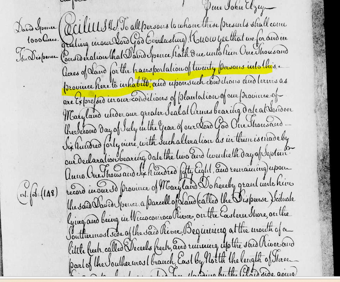
In the 1700’s many of the Patents and certificates held in the Archives of Maryland, were found to be in poor condition. Many of the early original documents were transcribed by hand to save the data for later generations. This task was very laborious in its nature, and required the feather of a bird and inks made from various ingredients. Although some of the originals were transcribed, they still remain in the collection today and are now digitized. So we now have access to both the transcribed and a small amounts of the originals documents. P.L.G.

Copy of the original document in Old Patent Liber AA folio 412, in poor condition but still legible.
Other early settlers in the area on the south side of the Wiccocomico AKA Rokiawalkin River
At this point I would like to show the location of another 1000 Acre Tract issued in 1664 to William Thomas, mentioned in the first part of this document called the Lott. Mr. Thomas was listed as one of the early settlers of Maryland. In the Google Earth picture below I have laid out the lines of the Tract called The Lott and that it’s northern or up river boundary is Dashiell Creek AKA Stone Creek today. The upper part of this tract will become part of Last Purchase and the location of that mysterious grave with the difficult inscription that we have been trying to read for over 30 years. Identifying the individual interred in that vault has been a challenge. Google Earth overlay on the next Page
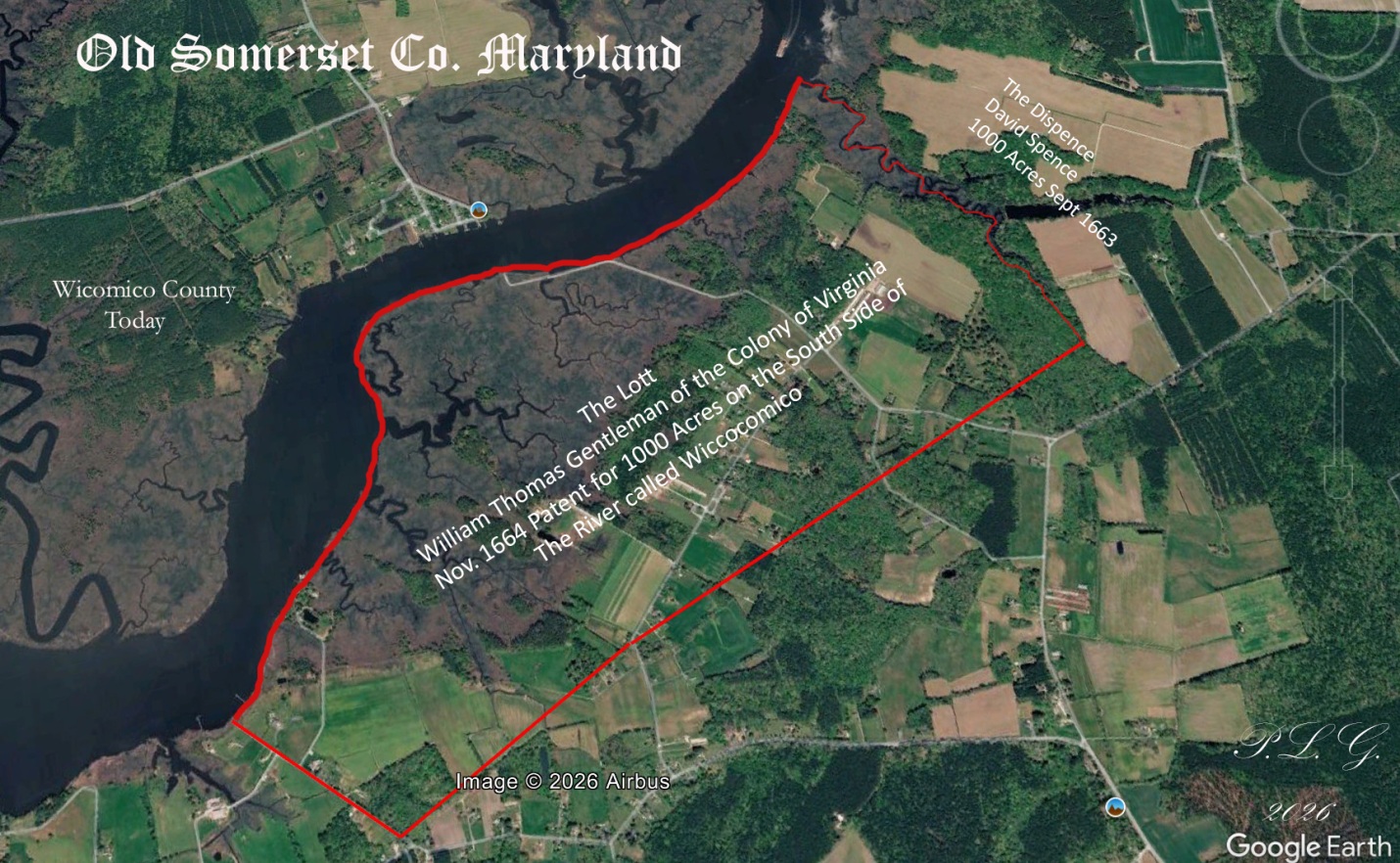
You can see in this overlay that Mr. Thomas’s holding contained a large amount marsh area that covered the entire northwest boundary along the River. This would not allow for any high banks for landings or wharfs, but more than half of the tract to the southwest was high farm land and forest. This area today is Mt. Vernon aka Hungary Neck. You can see that Dashiell or Stone Creek is the northeast boundary of The Lott and Despence.
Back to the verbiage within the Deed, in M 4 folio 232.
In June of 1668, James Dashiell and Ann his wife received the southwestern part of the tract called The Dispence in the amount of 500 acres from David Spence. In colonial times this was called a moiety, meaning a one half part of a tract. (Old French word meaning half). This deed is recorded in Somerset County Deed Liber B 1 folio 119. Remember David Spence transported James Dashiell and his wife Ann into the Colony of Maryland in 1663 and received 100 more acres in his patent. On the next page is a copy of part of the original deed from Liber B 1 folio 119. Also in this deed we find that David Spence’s wife is Anne. The money for this transaction is shown as available consideration, sort of hiding the actual money exchanged.
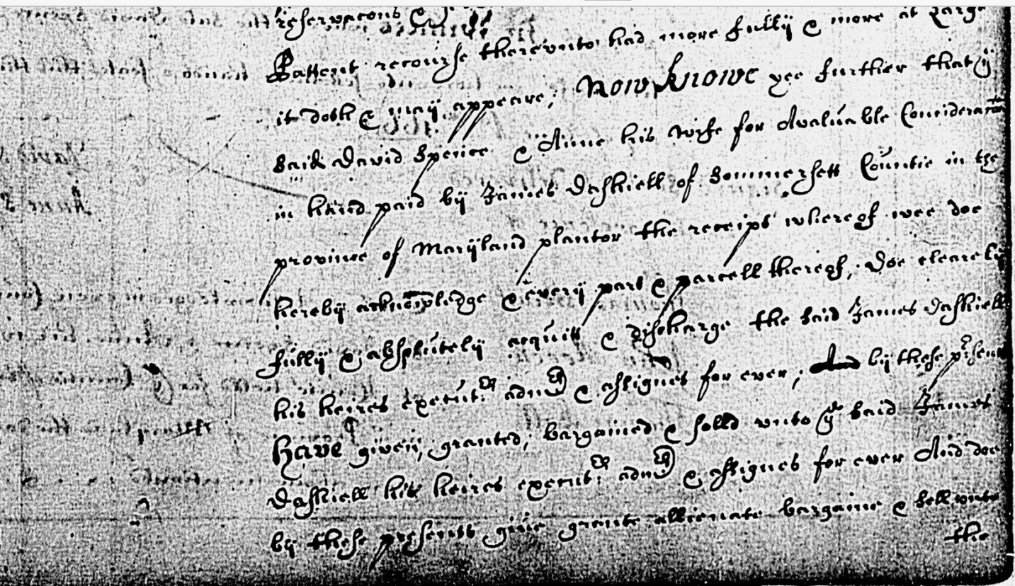
Document reads
Now Knowe ye further that ye said David Spence and Anne his wife for available consideration in hand, paid by James Dashiell of Somerset County in the Province of Maryland planter the receipt whereof we do hereby acknowledge and every part & parcel thereof, so clearly fully & absolutely equit & discharge the said James Dashiell his heirs appointed & assignees forever and by the above? Have given, granted, bargained & sold unto ye said James Dashiell his heirs, agents & assignees forever and doe by these presents, given, grant alienate bargain & sell unto the…………and so on.
On the next page is a protractor drawing by the Author of The Despence, divided into two 500 Acre parts. Northern part retained by David Spence and his wife. The southern part now held by James Dashiell and his wife by the above deed of Sale.
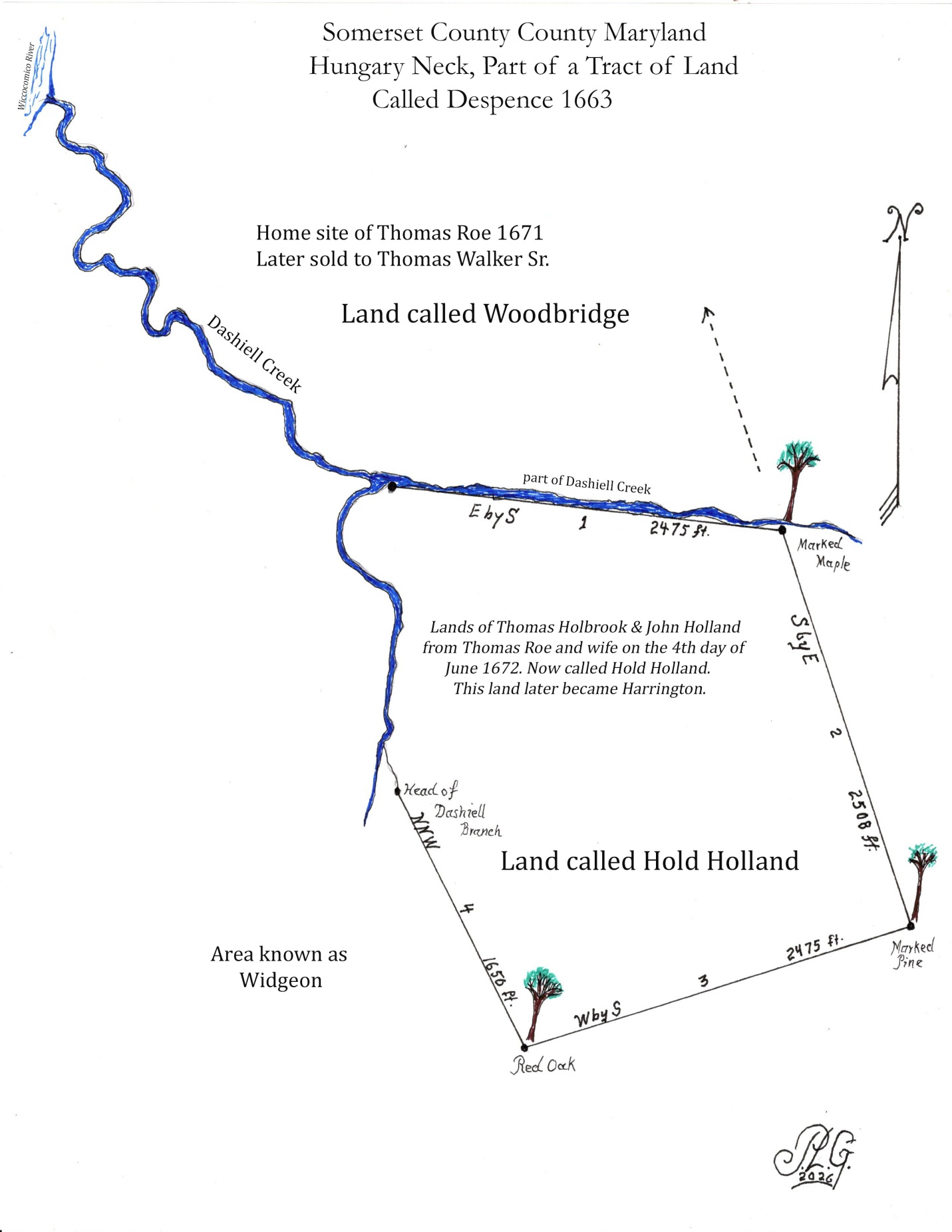
This gave Mr. James Dashiell two parcels of 250 Acers, one on the north side of the easterly branch of Dashiell Creek and one on the south side of the branch. This created a natural boundary for the two sections, which were sold later and patented under another name of Hold Holland, by Thomas Holbrook & John Holland.
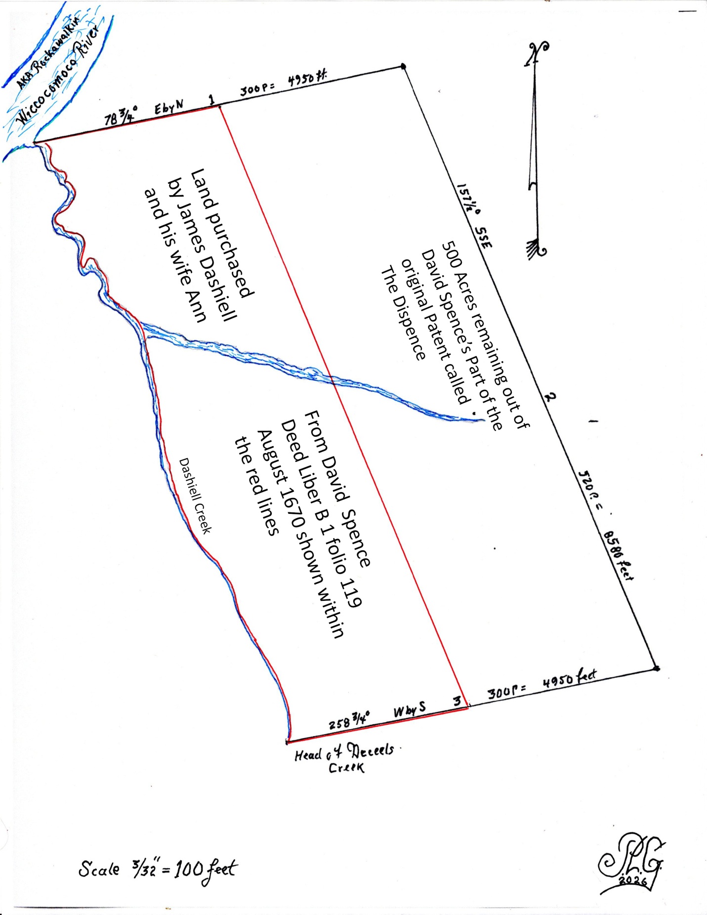
On the 9th day of August 1670 James Dashiell and wife Ann, for valuable consideration conveyed, sold and transferred by a deed of conveyance, their part of the tract called The Dispence to Thomas Roe of Somerset County. The land containing 500 Acres by estimate was transferred in fee simple to Thomas Roe and his heirs and assignees forever. Then on the 4th day of June 1672, Thomas Roe and his wife Ann by a deed recorded in the land records of the County. Sold and transferred to Thomas Holbrook & John Holland a part or parcel of 250 Acres. This was the lower part south of Dashiell Creek previously mentioned above.
Bound as follows: Beginning at a marked oak standing at the fork of Dashiell’s Creek and running up the creek East by South 150 perches to a bounded maple tree, then with a line drawn South by East 152 perches to a marked pine tree, Then West by South 150 perches to a marked red oak, then North, North West 100 perches to the head of Dashiell Creek, then down the eastern most side of the branch 50 perches to the first boundary. Containing by estimate 250 Acres more or less and is now called Hold Holland, now in the possession Thomas Holbrook and John Holland.
On the next page is a protractor drawing of the land called Hold Holland by the Author’ P.L.G. 2026
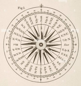
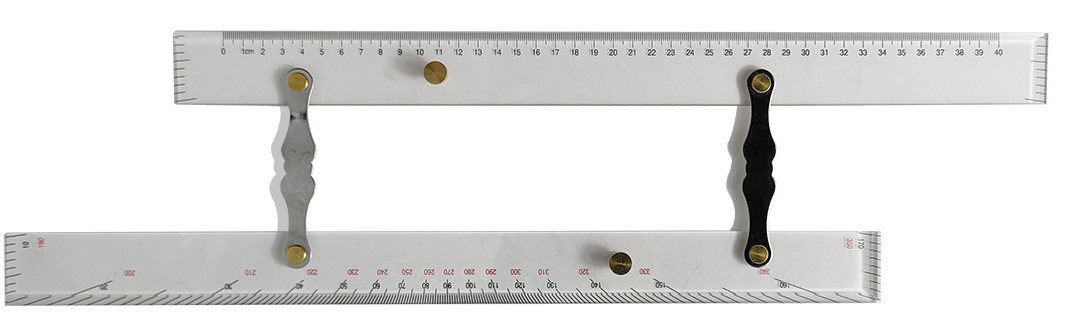
Many land patents and certificates of survey in this narrative were created by protractor drawings, because the original plats are not found in the Archive of Maryland. It is reported that some were lost or destroyed by fire in the early colonial period. In some incidents the author has drawn a protractor plat anyway to illustrate some special feature not shown in the original Plat.
Chapter Three: The Last Purchase of Thomas Walker
Now back to the deed M 4 folios 231-241
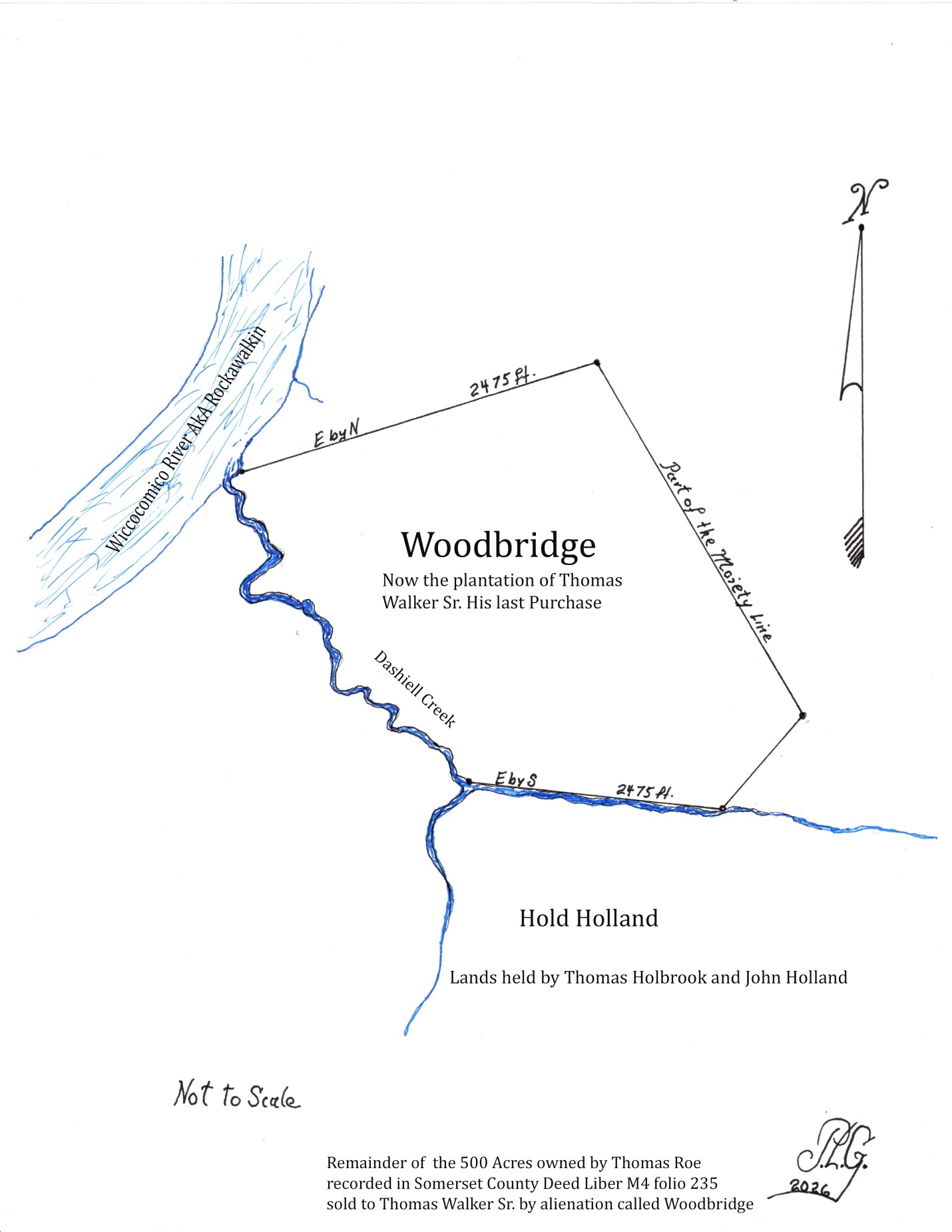
Now this Indenture, witnessed that the said Thomas Roe and Ann his wife for and in consideration of Ten Thousand pounds of Tobacco paid by Thomas Walker Sr. to the said Thomas Roe and Ann his wife, in hand paid. The receipt acknowledged for every part and parcel confirmed, bargained and sold unto him Thomas Walker 250 Acres now called Woodbridge. (Later discovered to be by estimation 242 Acres of land and recorded by the name Woodbridge). On the seventeenth of September in the year of 1675, Capt. Thomas Walker paid nine pounds of tobacco for alienation to William Coulbourne Sheriff of Somerset County for the tract called now Woodbridge. This was actually the last purchase of land for Capt. Thomas Walker Sr.
On the next page is a drawing of a plat made by the writer of the land called Woodbridge. No plat was found in the records of Somerset County. The drawing is not to scale, but shows the area of old Despence that was sold to Thomas Holbrooke and John Holland called Hold Holland. The northern part was called Woodbridge. There was a small piece of land added to Woodbridge called the Addition. (Addition is not shown on this drawing, but stood on the northern part of the property along the river).
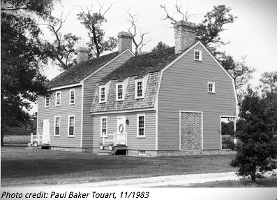
The southern part of the moiety later became the tract and Plantation called Harrington, shown below, still standing at this date. Harrington is registered in the Maryland Historical Architectural Survey file # S-83. National Registry.
Capt. Thomas Walker Sr. apparently arrived in the British Colony of Maryland in 1664 (Liber 10 folio 465) requesting land from the Colonial Government. Walker received 50 acres of land for transporting himself in to the colony. None of his early patents issued were for the lands in this study. Thomas Walker held many land patents in what was Old Somerset (now Wicomico, Worcester, parts of Delaware and present Somerset County). Some secondary records indicate that he held 7000 Acres of land at the time of his death. His final land was acquired by deed from Mr. Thomas Roe. Walker held many offices in Maryland and later Somerset County. Thomas Walker was assigned Gentleman Justice of the Quorum for Somerset County in 1679; High Sheriff of Somerset 1678; collector of Customs in 1676 and Councilor on Indian Affairs, and many more too numerous to mention here. Sources found in the Archives of Maryland Vol. 15. Capt. Thomas Walker was married to Jane Coppinhall in December 1674 by Capt. William Colbourne, later to become a great friend of many in the gentry of Maryland. Tom and Jane his wife had two children; Thomas Jr. born March 11, 1675 and Susannah, born the following year. Walker died in 1680 and was buried on his plantation now called Woodbridge. His will was short and to the point, wrote on May 1, 1680, probated the following year. His wife Jane was executrix, and his land reported to be over 7000 acres was inherited by his two children. Most importantly he was the great, great grandfather of Samuel Chase, one of the signers of the Declaration of Independence. In his inventory recorded in Annapolis Inventories and accounts Book 7 Part B page 98 is a store house of valuable items. Thomas was a sea captain with great experience and knowledge of shipping. The inventory appraised by Capt. Henry Smith and William Brereton included ships, rigging, hawsers, ropes and much more too large for this narrative. His household items were just as impressive, including feather beds, broadcloths, linens, frocks, linsey Woolsey gowns, and furs to mention a few. In his hall it was reported that he possessed Bandoleers, pistols, and swords. The bed chambers were furnished with fine carpet, rugs and blankets. On the plantation he held many farming items related to the farming operations. He had white servants and held two Negro slaves. The plantation was home for 100 horses and cattle valued at 200 lb. Sterling. See the appendix for more information.
Chapter Four: Thomas Walker Jr.: Lands of His Father
Thomas Walker Jr. (c. 1675–before 1744) of Somerset County, Maryland, was the maternal grandfather of Samuel Chase (1741–1811), the Declaration of Independence signer. Walker was a wealthy merchant and planter whose daughter, Matilda Walker, married the Rev. Thomas Chase in 1740. Thomas had married Sarah Maddox in 1697 in Somerset County. Thomas Walker Sr. in his will 1681 bequeathed to his son Thomas Walker Jr. the plantation that I now live upon lying and being on the south side of Wiccocomico River. Also the land I lately took up adjoining. (The land connected to Woodbridge called Addition located on the north side of the plantation). He gave unto his son Thomas Walker Jr. and daughter Susannah Walker all other lands where ever they may lie, to be equally divided, share and share alike. The will was probated the following year with his wife Jane executrix.
On June 9, 1724 Thomas Walker Jr. received a Patent under a special warrant to resurvey a part of a tract of land called Despence, patented originally to David Spence. This resurvey included several vacant lands and one addition called Woodbridge the land of his father. This survey resulted in a new patent called Last Purchase issued to Walker on March 17, 1728. Containing 618 acres of land. The tract is shown on a drawing by the writer on the next page. Note this would conclude that Thomas Jr. live in the same house of his father Thomas Sr. Also the home place of Thomas Roe.
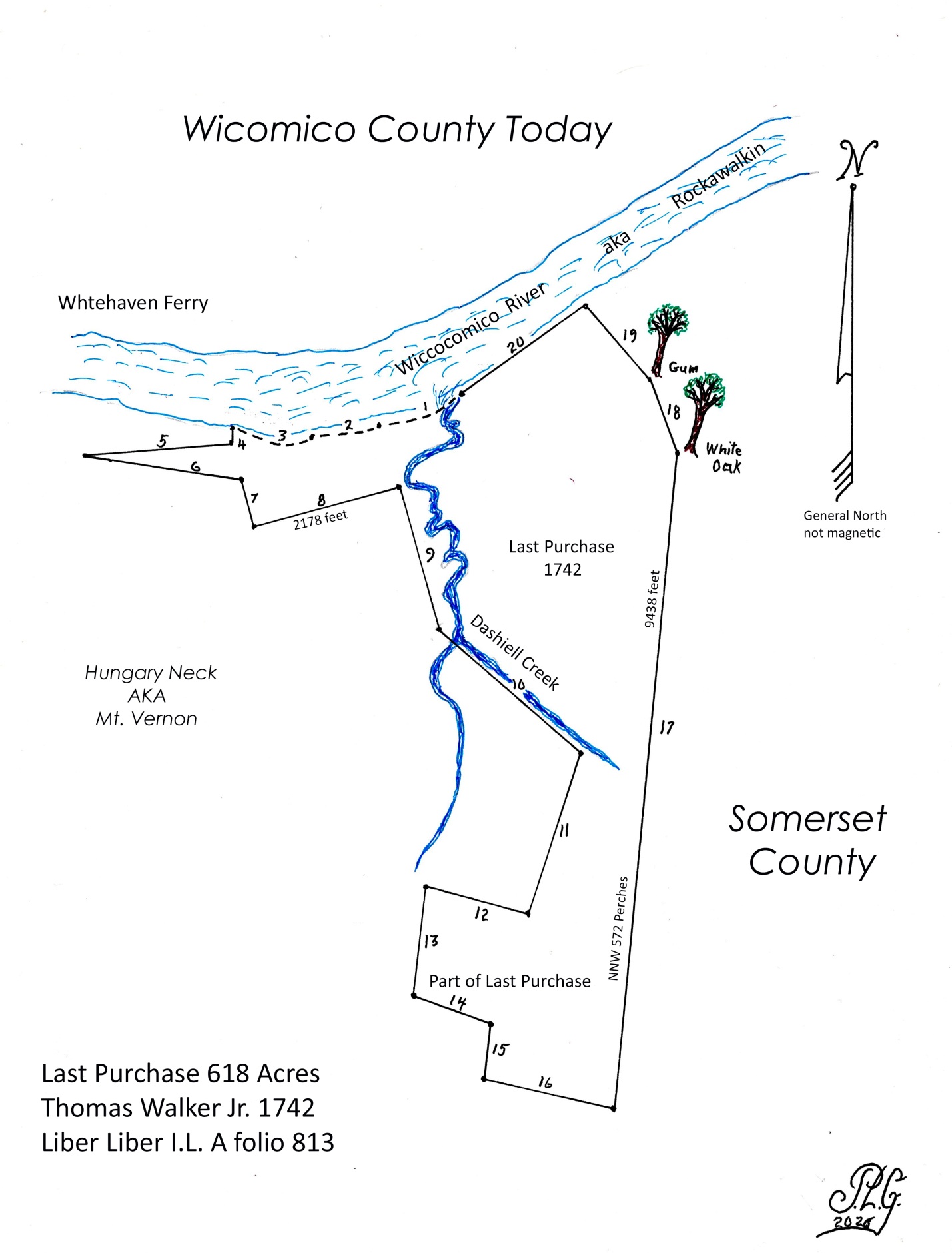
Google Earth overlay of Last Purchase of Thomas Walker Jr. lands, with cemetery data.
Thomas Walker Jr. lived the pleasant life with good circumstances; He married in 1697 to Sarah Maddox daughter of Lazarus Maddox of Manokin. They had the following children: Ann, Eleanor, Elizabeth, Jane, Mary, Matilda, Rebecca, Sarah and Thomas. He died in 1744 leaving behind by him a good name and a large estate that gave his children a prosperous life. His will dated Dec. 29. 1744 (Liber DD # 2 folio 674 Annapolis wills) He devised the home plantation with all lands attached on the north side of Dashiell’s Creek, to Jacob Sarly for his children by his daughter Elizabeth Sarly (She had married Sarly, date not found). Note; see biography in appendix for more information
At this point it is important to give a narrative of the man, Captain Jacob Sarly a well-known New York Privateer, merchant and slave trader. Some transcripts and secondary sources such as ancestry, Wikipedia and others are not clear on the surname of our subject. In the original will of Thomas Walker Jr. he leaves his land and plantation were he now lives to Jacob Sarly for his children by Elizabeth Sarly. (In some records his name is shown as Daily, Galey and Sarley) causing some confusion for some researchers. The primary sources reveal the name as Jacob Sarly, a Sea Capt. And Merchant in New York. Sarly was a member of the New York merchant firm of Sarly and Barnewell. Robert Dashiell of Somerset Co. in his probate records, Dashiell specifically leaves a substantial sum of 60 pounds Sterling to Jacob Sarly, now living in New York. The Dashiell family owned expansive tracts of land along the Wiccocomico River, which served as a crucial hub for trade and navigation in the Colony of Maryland. The maritime and merchant career of Jacob Sarly operating as a merchant and sea captain commanding vessels like the Indiaman America (armed merchant vessel) and various regional sloops. He frequently conducted trade along the Atlantic coast, including routes through Maryland and the Chesapeake Bay. Sarly later became a member of the New York merchant firm Sarly & Barnewell and corresponded directly with figures like Alexander Hamilton and Thomas Jefferson regarding maritime and consular trade matters. Outside of his Maryland trade connections, Captain Sarly was prominent in American colonial history for his involvement in the 1741 New York conspiracy trials. (Negros Uprisings) He testified as a slave owner in the defense of a Spanish-speaking black sailor named Juan de la Silva. It was reported that Jaun was the ring leader in a plot to burn the city. A fire broke out in April of 1741 right next to Capt. Sarly’s home. At a trial held later, Sarly argued that Juan was a faithful servant who actually raised the alarm for one of the New York fires that broke out. Juan was ultimately convicted amidst the city’s wartime hysteria and was later executed for his involvement. This apparently indicates that Juan was a servant of Capt. Sarly.
In the probate records of New York Sarly appears in the will of a free black man named John Fortune. It reads, In the name of God Amen, I John Fortune of the City of New York a free Negro publish my last will and testament. He gives and devises to his wife Nancy all of his worldly estate, real and personal to dispose of as she see fit. He states in the will that he finds himself possessed of a Negro slave Girl named Lizey, my will respecting her is that she continues to serve my wife Nancy during her natural live if my wife thinks it is advisable to do so. In the case that my wife should die before me I desire that the girl be freed at her own disposal. During the life time of my wife if the girl does not please my wife, I empower her to sell the girl to persons she thinks proper at the price she feels appropriate. I do hereby declare that the bill of sale or other instruments to sell the said Negro Girl, be proper and good by the law. I hereby nominate my friend Jacob Sarly and Daniel McCormick of the City of New York merchants to be my executors of this my last will and testament. Will signed the twenty second day of August, 1795. (John X Fortune). Old will Liber folio 85-86 City of New York. Will probated twentieth day March, 1812 Ancestry files online.
No will was found for Jacob Sarly or Elizabeth Sarly.
Matilda Walker, marries Rev. Thomas Chase
The Reverend Thomas Chase married Matilda Walker, daughter of Thomas Walker & Sarah Maddux on March 17, 1739. Somerset’s native son, Samuel Chase was born on April 17th 1741, only child of Reverend Thomas Chase and Matilda Walker, his mother died giving birth to her son Samuel. It appears to be obvious that our subject was born on the Last Purchase plantation, and for some years of his youth grew up and played on this Wiccocomico plantation. Samuel Chase studied law after leaving Somerset around 1759. Elected to the Maryland General Assembly in 1764, he served in that capacity for twenty years, and represented the colony at the Continental Congress, ultimately signing the Declaration of Independence. Of the Revolutionary War years he wrote in 1777, “Tories have been gathering in Sussex, Worcester and Somerset counties for several days. They have 250 men collected at Parker’s Mill about nine miles from Salisbury with the intention to seize the Magazine and destroy the property of the Whiggs.” Another prominent local resident during the Revolutionary War years, Luther Martin, who later became Maryland’s first Attorney General, resided near Princess Anne in 1777 and commented that There was a period of considerable duration throughout which, not only myself but many Others, did not lay down one night in our beds without the hazard of waking on board a British armed ship, or in the other world. The lower Eastern Shore patriots had much to protect along the region’s navigable waterways, where Tory activists preyed on plantations and shipbuilding sites. While loyal patriots fought local Tory insurgents as well as British raiding parties, lower Eastern Shore planters also aided in feeding the Continental Army by sending foodstuffs north to the Head of the Elk River. This endeavor was known as the Bread Basket of the Revolution. The author’s 5t generation grand-father, The Honorable Robert Goldsborough of The Point plantation in Cambridge, Maryland also was one of the founding fathers. Serving in all three of the Continental Congresses in Philadelphia, and would have signed the Declaration of Independence, if not for a bad case of gout. The Declaration was adopted unanimously on July the 4th 1776, but was signed by members throughout the month of August. Robert was at the time working on the forming of Maryland’s first constitution and reported to have said, “I was not going to travel 4 days in a stagecoach, in the heat of August, to put pin to a document that I was on record of voting in favor off and would have been hung with the others if the Revolution had failed.” My work was more important in the Colony of Maryland at the time. Robert and the Goldsborough family were also involved in the Bread Basket project, and had barges with canon patrolling the Miles River near their homes.
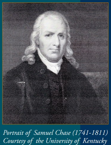
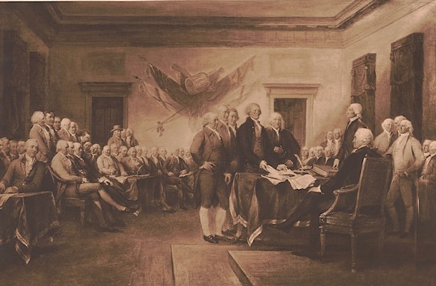
This document was being researched and written in the month of July 2026, during the Semiquincentennial celebration of our Nation.
Chapter Five: Capt. Thomas Waters: Land Now Called Chance
Now back to the land title passing eventually to Capt. Thomas Waters
Captain Thomas Waters, son of William Water Sr. (abt. 1705-1781) and Rose Anne Harmanson (abt. 1714-1760) married first to Margaret Lucas abt. 1750 and died abt. 1798. Source; (From the files of Edward M. Smith, local genealogist and historian of Upper Fairmount, Somerset County, Md.)
Thomas married second to Susanna Jacob born apt. 1753 in Northampton County, Virginia. She was listed as an orphan of Isaac Jacob c.1720-c.1763, and chose a guardian in Dec 1767 in the county of Northampton. Thomas Waters was her third marriage. In her husband’s will she is listed as Ext. (Miles Files)
The following deed is the deed recorded in the Somerset County, land records showing Capt. Thomas Waters as the grantee of the lands called Last Purchase. Below is a partial copy of the deed sometimes difficult to read, but contains the genealogy, land description and legal right to the land and how the chain of title is followed.
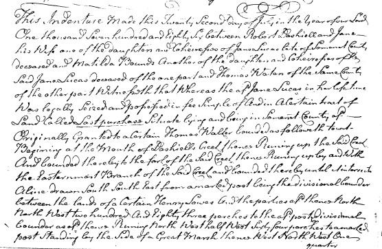
Below is a transcript of the Deed Liber H folio 170 dated July 2, 1786 a highly technical document but shows the legal procedure in a deed in early Maryland making an absolute transfer of land and with warranty and description by the surveyors, but not necessary to read to follow this story.
This Indenture Made this Twenty Second Day of July in the Year of our Lord One thousand Seven hundred and Eighty Six Between Robert Dashiell and Jane his Wife one of the Daughters and Coheirs of Jane Lucas late of Somerset County deceased and Matilda Bounds Another of the daughters and Coheirs of said Jane Lucas deceased of the one part and Thomas Waters of the Same County of the other part Witnessed that Whereas the said Jane Lucas in her life time Was legally Seized and possessed in fee Simple of and in a Certain tract of Land Called Last purchase Situate lying and being in Somerset County aforesaid Originally Granted to a Certain Thomas Walker bounded as followeth to witness Beginning at the Mouth of Dashiells Creek thence Running up the said Creek And bounded thereby to the fork of the Said Creek thence Running up by and With the Easternmost Branch of the Said Creek and bounded thereby until it intersects A line drawn South, South East from a marked post being the divisional bounder between the lands of a Certain Henry Lowes And the parties aforesaid, thence North, North West two hundred and Eighty three perches to the said post divisional bounder as aforesaid thence Running North West half a point West Sixty four perches to a marked post Standing by the Side of a Great Marsh thence West North West One quarter North One hundred and four poles to the side of Wicomico River and from thence bounded down by and With the said River to the first beginning Containing and Laid Out for three hundred and twenty two Acres and One half of an Acre of Land, more or Less And the aforesaid Jane Lucas being seized and possessed of the aforesaid Lands and premises as aforesaid Died so thereof seized and possessed leaving her three daughters to wit the said Jane Dashiell and Matilda Bounds and Margaret the Wife of the aforesaid Thomas Waters party to these presents her Coheirs at law to Whom the Lands descended in fee simple as Copartners on the death of the aforesaid Jane Lucas And by which said parties the said Lands and premises have been held and possessed in Common And undivided since the death of the said Jane Lucas Now this Indenture further Witnesseth that the said Robert Dashiell and Jane his Wife and Matilda Bounds for and in Consideration of the sum of One hundred and forty five pounds Current Money of Maryland to them in hand paid by the aforesaid Thomas Waters before the Sealing and Delivery of these presents the Receipt Whereof the said Robert Dashiell and Jane his Wife and Matilda Bounds do hereby Acknowledge And thereof do Acquit and Discharge the said Thomas Waters And his heirs Executors Administers and Assigns forever have bargained and Sold Released Conveyed And Confirmed And by these presents do bargain And Sell Release Convey And Confirm unto the said Thomas Waters and his heirs and Assigns forever all their undivided two third parts of the Lands and premises Above described with all and Singular the Appurtenances thereunto belonging or in any Manner appertaining and all the Right and title Claim and interest Which they the said Robert Dashiell and Jane his Wife and Matilda Bounds have either in law or equity of in And to the above described premises or any part thereof. To have and to hold the aforesaid undivided two thirds of the aforesaid described tract or parcel of Land With all the Right And title in law or Equity of the Above said Grantors to the aforesaid described premises or any part thereof with all and singular the Rights privileges and Appurtenances thereunto belonging or in Any Manner appertaining to him the said Thomas Waters and his heirs and assigns forever to and for the only proper Use benefit and behalf of the said Thomas Waters and his heirs and assigns forever and for no other use intent or purpose whatsoever and the said Robert Dashiell and Jane his wife and Matilda Bounds for themselves and their heirs do hereby further Covenant Grant and Agree to and with the said Thomas Waters and his heirs and Assigns forever that they, the said Robert Dashiell and Jane his wife and Matilda Bounds and their heirs Will Warrant And forever defend the aforesaid Lands and premises above described And intended to be Conveyed to the said Thomas Waters and his heirs and assigns forever against the claim right and title of the said Robert Dashiell and Jane his wife and Matilda Bounds and their or either of their heirs or any other person or persons claiming from by or under them or any or either of them and the said Robert Dashiell and Jane his wife and Matilda Bounds do further covenant and agree to and with the said Thomas Waters and his heirs and assigns that they the said Robert Dashiell and Jane his wife and Matilda Bounds and their heirs will from time to time and at all times hereafter at the reasonable request of the said Thomas Waters or his heirs or assigns and at his or their proper cost and charges in the law legally make Execute And Acknowledge any further act or acts deed or deeds which shall by the said Thomas Waters or his heirs or assigns or his or their council learned in the Law be advised devised or required for the further and better securing the Lands and premises above described and intended to be conveyed by these presents to the said Thomas Waters and his heirs and assigns forever provided that the said further or other act or acts deed or deeds shall contain or express no further or other covenant or clause of warranty then what is contained and expressed in these presents In Testimony Whereof the said Robert Dashiell and Jane his wife and Matilda Bounds to these presents lay their hands have set and seals affixed the day and Year above Written. Sealed and delivered in Maryland In the presence of George C. Gale be it remembered that on the day and year written within John Stewart personally appeared before us the Subscribers two of the Justices of the peace for the County aforesaid, the within named Robert Dashiell and Jane his wife and Matilda Bounds and the said Robert Dashiell and Matilda Bounds did acknowledge the within writing of conveyance to be their act and deed and the Lands and premises therein mentioned and intended to be conveyed to be the right title and property of the said within named Thomas Waters and his heirs and assigns forever according to the true intent and meaning of the said deed and the said Jane wife of the said Robert Dashiell being by us privately examined apart from and out of the hearing of her said husband. Did acknowledge the said writing of Conveyance to be her act and deed and the Lands and premises therein mentioned and intended to be conveyed to be the right title and property of the said Thomas Waters and his heirs and assigns forever according to the true intent and meaning of the said deed and declared that She made her said acknowledgement willingly and freely and without being induced thereto by fear or threats of or ill usage from her said husband or for fear of his displeasure according to the directions of the Act of Assembly in such case made and provided --- Before John Stewart, George C. Gale Recorded in Liber H folio 170 & 171 & 172 on the Twenty fourth Day of August Anno Dom 1786
Tested; Thomas Hayward Clerk.
End of Liber H
The deed above indicated the description with metes and bounds of Thomas Water’s, land, being part of the original survey called Last Purchase, but apparently had not been properly surveyed. So six years later he was issued a new patent and the land was resurveyed and a plat recorded.
On June 13, 1792 a tract of land called Chance was surveyed for Captain Thomas Waters, containing 559 ¼ Acres, Certificate 474 Somerset Co. Md. His certificate was examined and passed March 21, 1793, but was not patented until December 9, 1806. On the Certificate it was noted and recorded that Mr. Thomas Hollbrook, wanted it known that the tract adjoined his property.
The tract of land called Chance was patented under a warrant to resurvey the tract of land called Last Purchase, which was purchased from Robert Dashiell and wife on July 2, 1786, and recorded in Som. Deed Liber H folio 170. (Shown on the previous pages above) Surveyor’s found that 84 ¼ acres had been taken from Last Purchase by and earlier tract called Harrington in possession of Mr. Thomas Holbrook.
They also found 19 Acres of land Vacant which was added to the survey. New metes and bounds were recorded and a plat drawn and recorded in the Somerset County land records.
Plat shown on the following pages.
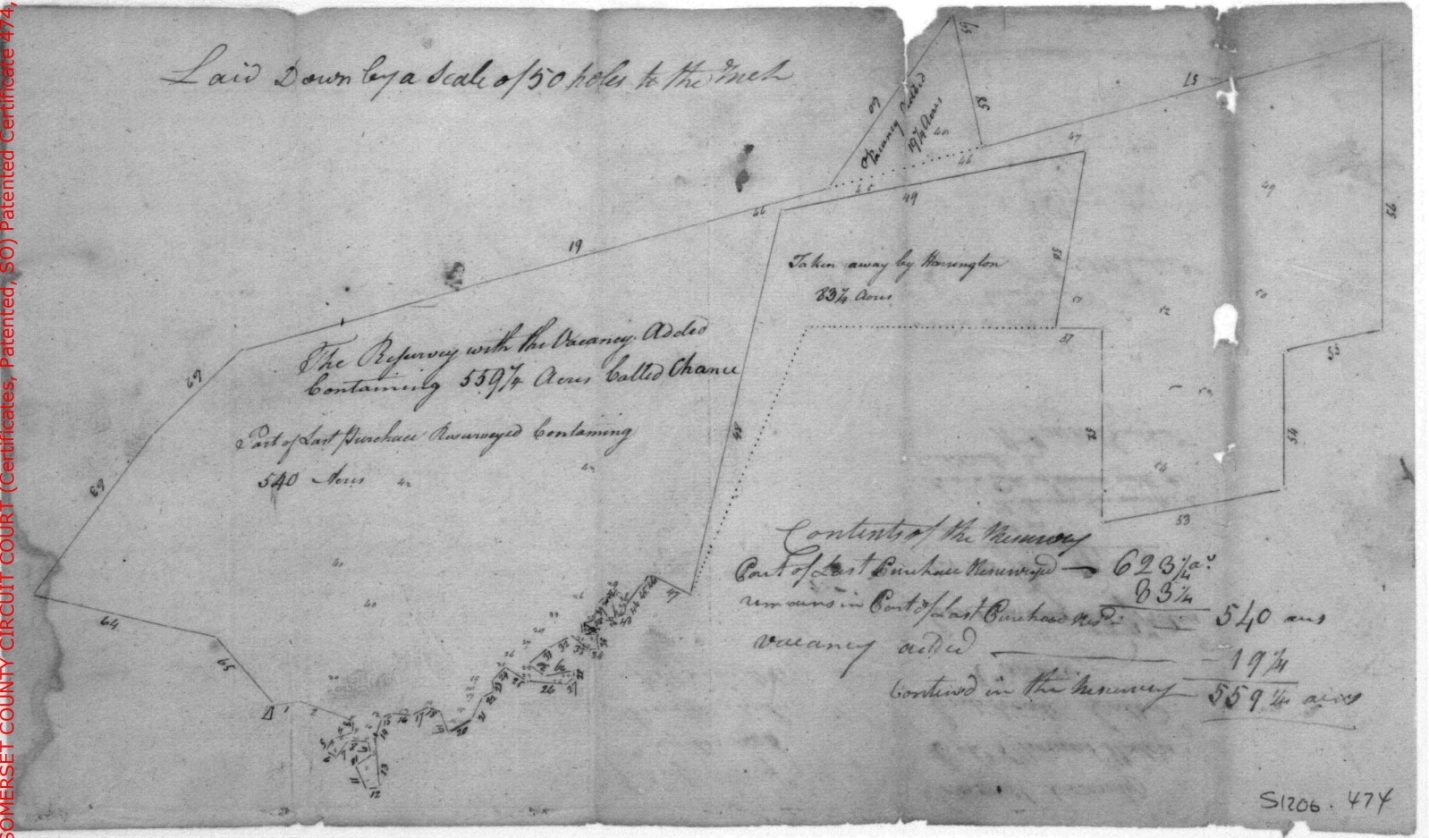
Surveyed for Captain Thomas Waters 13 June 1792, patented on 9th day of December 1806 and recorded in Patent Liber J.C. #S folio 419, Maryland State Archives, Annapolis, Maryland.
On the next page is an overlay placed on Google Earth and stretched to the correct measurement of the boundary lines and angles described in the verbiage of the survey report.
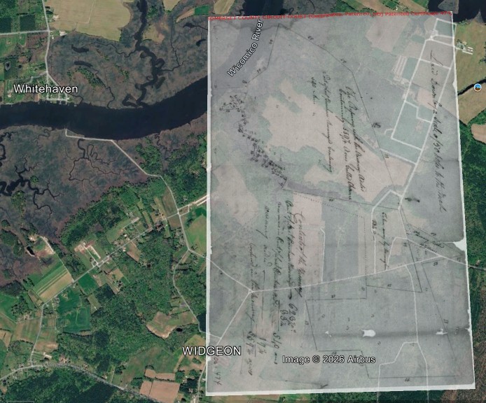
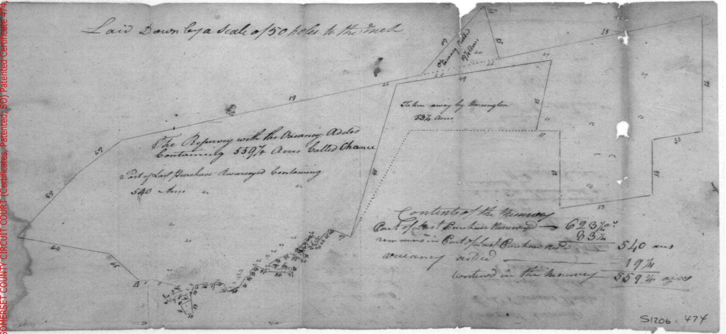
Note where the dotted lines shows the acreage lost to Chance by the tract called Harrington, held by Thomas Holbrooke. Mr. Thomas Holbrook became the neighbor of Mr. Waters he also was a large land owner in the area of Hungary Neck. Known as a Planter & Gentleman Mr. Holbrook’s family lived in this location for about 120 years acquiring close to 1,000 acres and building a log house 16 x 14 originally near the “Witch Bridge”. He later built a Home in plain order in the Georgian style, which still stands.
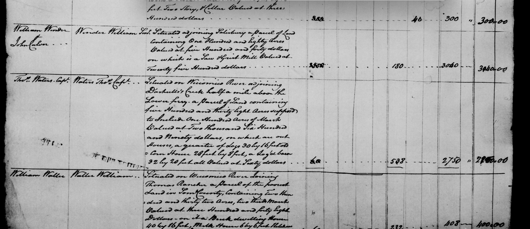
Thomas Waters listings in the 1798 tax list are shown below
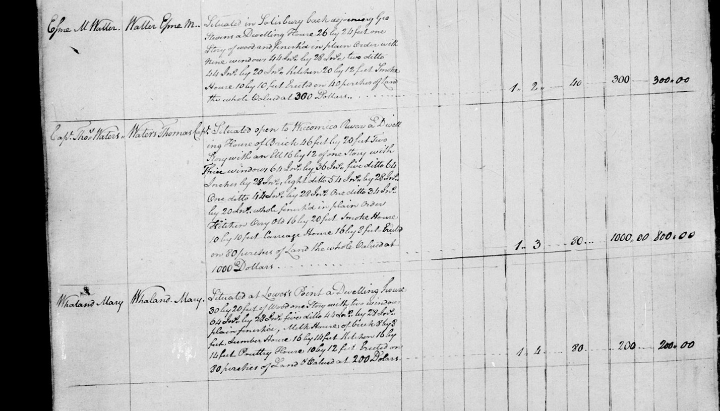
When Thomas Waters was born about 1745, shown in Coventry Parish Church records, Somerset, County, Maryland, British Colonial America, his father, William Waters Sr., was 51 and his mother, Rose Ann Harmanson, was 33. He married the second time to Susanna Jacob on 20 April 1799, in Northampton, County, Virginia, United States.
In the 1798 Tax list for Wicomico Hundred he is listed as Capt. Thomas Waters living on his own land. Situated on Wiccocomico River adjoining Dashiell’s Creek half a mile above the lower ferry. A parcel of land containing five hundred and thirty Eight Acres supposed to include 100 Acres of Marsh valued at two thousand, six hundred and ninety dollars, on which are out houses, a quarter of logs 30 by 16 feet, old corn house 28 x 8 feet a log barn 32 by 20 feet all valued at sixty dollars.
Under houses & Wharfs he is situated open to Wiccocomico River a Dwelling House of Brick 46 feet by 20 feet two story with an ell 16 by 12 of one story with three windows 64 in. by 36 in. five ditto 64 inches by 28 in., eight ditto 54 in. by 28 in., one ditto 44 in. by 28 in. one ditto 34 in. by 20 in.. Whole furnish in plain order Kitchen very old 16 by 20 feet, smoke house 10 by 10 feet, Carriage house 16 by 8 feet, erected on 80 perches of land the whole valued at 1000 dollars
Note; In the 1798 tax, known as the glass tax, the kitchen is noted above as being very old. This tax called the glass tax was coined because the owners were taxed for the number of glass window in the dwelling, So many wealth land owner placed many windows in the structure to show off their wealth. P.L.G.
Thomas died before 18 April 1817, in Somerset, Maryland, United
States, and was buried in the Waters Cemetery, Mount Vernon, Somerset,
Maryland, United States. His will was made March 1, 1817 and probated on
April 18, 1817. Document recorded in Som. Wills EB #23 folios
252/253.
Below is the Cemetery Teams report dated 6 Feb, 1994, a cold damp day as
I remember, in late afternoon. P.L.G.
WATERS CEMETERY
General Description: Mt. Vernon Election District No. 5 (Hungary Neck No. 5 1877 Atlas of the Eastern Shore). Located one mile north of the small community of Widgeon and near the home of Dr. T.W. Stone on the 1877 Atlas.
Exact Location: 38 degrees 16’ 15” North Latitude
75 degrees 46’ 05” West Longitude
The markers that we found on this site appear to have been moved from their original location. They were likely moved by someone to protect them from farming operations. The stones are leaning against some trees at the edge of a field, near a creek making out of the south side of the Wicomico River. These are handcut stones.
S.W.
1831
In Memory of
Capt Thos Waters
who died 1817.
In Memory of
Mrs. Susanna Waters
who died 1831
Footstone
E. S. S.
Listed Sunday, 6 February 1994 by Martha Johnson Parks, Philip L. Goldsborough and Rebecca F. Miller. Note: Rebecca F. Miller is now deceased one of the original members of our team.
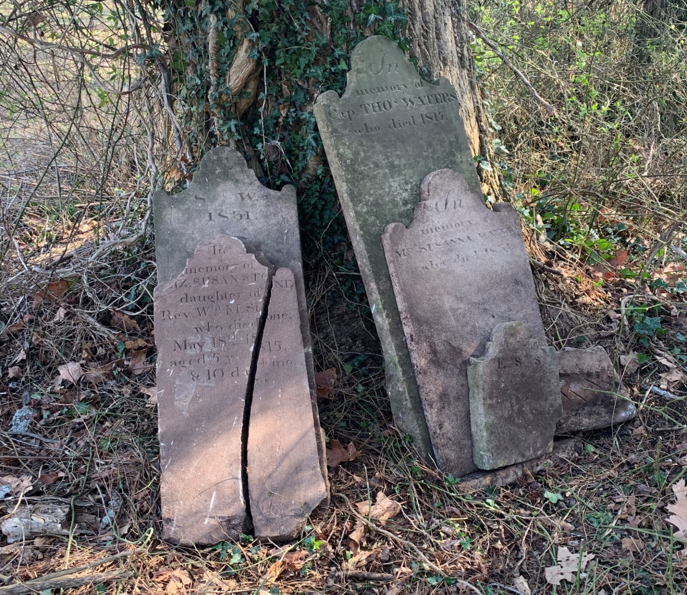
Waters Cemetery on the tract of land called Chance.
This cemetery has been disturbed by development in the 1960s. Stones were put in the brush at the edge of an arable field in cultivation on the last visit, in April of 2026 by Edward Smith, Philip L. Goldsborough, Brice Stump and Freddy Howard. Only the stone of Thomas Waters was found leaning against a tree when we arrived that day. Susanna Waters, and the Daughter of Rev. Wm. Stone and some foot stones were relocated by probe, dug up and placed against the same tree. After considerable probing and digging, no Walker family tombstones where found at this location, and must be somewhere else on the property, we do plan to return to probe nearer to the house location sometime in the future, God Willing.
Chapter Six: Susanna Waters, Widow of Captain Thomas Waters, Inherits Chance
Thomas Waters in his will only bequeathed one Item: I give unto my dear wife Susannah Waters the whole of my estate, Real and personal, to her and her heirs forever. Also lastly, I do hereby constitute and appoint my dear wife Susannah Waters to be my sole Executrix of my last will and testament, revoking and annulling all former wills by me here to fore made, ratifying and confirming this and none other to be my last will and testament. In testimony whereof, I have here unto set my hand and affixed my seal, this first day of March in the year of our Lord one thousand eight hundred and seventeen. 1817 Note; see complete will in the appendix.
On the ninth day May in the year 1818 Susan Waters is buying more land which apparently did adjoin her lands called Chance from Mr. Henry White of Somerset County, and was recorded in Somerset County Deed Liber JD 3 folio 407 in the consideration of three hundred and fifty dollars current money of Maryland, USA. A parcel of land called Kelso being in the county and lying on the south side of the Wicomico River, and on the south side of Dashiell’s Creek near the lands of Susan Waters. Which tract of land was sold to Henry White by Thomas Holbrook in liber J.D. #D folio 522, 523 & 524. Starting at a white barked red oak a boundary of a tract of land called Hobbs Conclusion. Containing and laid out for twenty acres of land, more or less. This extended her land to the south and according to the Deed adjoined her tract called Chance and its patent name was Kelso.
On the 25th day of August, 1826 Susan Waters purchased another part of a patent called Bengal, surveyed for Thomas Holbrook owner of the land called Harrington. Susan’s part was on the south end of her lands. She acquired 32 & one half acre of Bengal from Joseph Cantwell by deed and recorded in the Somerset County land record GH 3 folio 290. Susan at this time had acquired a total of 611 and ¾ acres of land and still held the old home place on which many families had lived in our story. According to her tombstone Susannah aka Susan Waters died in 1831 on her plantation and was buried in the Waters family cemetery near Dashiell Creek. Coordinates 38 degrees 16’ & 15”north latitude, 075 degrees 46’ & 05”west longitude by GPS.
On the next page is a transcript of her last will and testament. See the original in the appendix.
Transcript of the Last Will & Testament of the late Susan Waters
Maryland Somerset County, to wit: - In the name of God, Amen. I Susan Waters of the State & County aforesaid, being of sound, disposing mind, memory & understanding considering the certainty of death and the uncertainty of the time thereof and being desirous to settle my worldly affairs thereby being the better prepared to leave this world when it will please God to call me hence, do therefore make this my last will and testament in manner and form following, that is to say – I give & bequeath unto my nephew Thomas Waters Stone son of William M. Stone & Ann Stone my niece deceased, the plantation whereon I now live, being on the south side of Wicomico river, the small tract of land purchased of Henry White, also the small tract of land bought of Joseph Cantwell to him the said Thomas Waters Stone and his heirs forever, except two acres hereafter to be left to Milly & Flora during their natural lives & at their death to return to the aforesaid Thomas Waters Stone & all the property I leave him I hereby leave under the care & direction of his father the Revd. William M Stone, the rents & profits of said lands to be applied to the education & maintenance of the said Thomas W. Stone until he arrives to the age of twenty one, the said plantation and buildings to be kept in repair, & no waste of timber suffered or permitted. I also leave to the said Thomas Waters Stone my glass lamp large looking glass, clock, one large Mahogany table, brass andirons, fender, family pictures, & china bowl second choice to him the said Thomas W. Stone & his heirs forever, & two bed bedsteads & furniture second choice. Item I give & bequeath unto my nephew James Murray Stone son of William M Stone & Anne Stone my niece deceased, my plantation near Green hill on the North side of Wicomico River, to him the said James Murray Stone & his heirs forever, the rents & profits to be applied to the education & maintenance till he arrives to the age of twenty one, to be under the care and direction of his father the Reverend William M Stone the said plantation and buildings to be kept in repair & no waste of timber to be permitted or allowed. I also leave the said James M Stone my Mahogany Secretary, gold watch, one mahogany table, beauroau, tea table, large droping flap, all my books, silver ladles, six silver tea spoons marked I S two beds, bedsteads & furniture complete first choice six silver desert spoons silver tongs, two pair silver salts, two pair silver shovels, my largest china bowl my set of tea china, spoons & tongs, one bay mare Fanny, negro boys Jesse & Thomas Waters sons of Nanny deceased & Arnold son of Pat deceased to serve him until the year eighteen hundred & forty six, at the expiration of which time the above named negroes to be free & in the meantime not to be hired out of the county nor sold for a term of years, also the crop or the rent of the farm left him as the case may be the year I die & one hundred & fifty dollars to him the said James M Stone & his heirs. Item I give & bequeath unto John Wilmer Stone son of William M Stone & Anne Stone my deceased niece six table spoons marked IDS & one china bowl to him the said John Wilmer Stone & his heirs also a black horse called Liberty & six tea spoons marked IDS. Item I give & bequeath unto William Murray Stone son of William M Stone & Anne Stone my deceased niece one horse bridle & saddle the best that can be bought for eighty dollars, to be purchased out of the residue of my estate to him the said William M Stone & his heirs. Item I give & bequeath unto Anne Stone daughter of the Revd. William M Stone & Anne Stone my deceased niece my droping table, her uncle’s miniature picture, my large easy chair, castors & all my wearing apparel to her & her heirs. Item I give & bequeath unto my deceased husband’s niece Eliza Ann Washington Covington daughter of Thomas Waters one hundred & twenty dollars, one bed bedstead bolster & two pillows fifth choice the money to be paid out of the residue of my estate by my Executor. Item I give & bequeath unto my friend Polly Dorman now living with me fifty dollars to be paid by my Executor the use of my hall during her single life, part of the garden the privilege of raising poultry for her own use fire wood to furnished her & Easter to wait on her while she lives here & when the said Easter is grown up she is to serve her mother Phillis until she is twenty one & then to be free the place for her use while she lives on it & remains single & to have provisions for herself out of the stock and on the year of my death – Item I give & bequeath unto Nelly & Joshua during their natural lives two acres of land on the water near the cow gut landing to be designated by my Executor my loom with all the weaving implements, her granddaughter Charlotte until she arrives to the age of twenty one & her daughter Sarah & her grandchildren to be permitted to live with Nelly & Joshua & no one else to have the use of the quarter twelve months until she can get her house built & to keep two hogs & a cow & calf & to cut no wood to burn or build with but box wood the said Charlotte to be free at the age of twenty one years – Item I give & bequeath unto Carkey during her natural life two acres of land to be situated on Cashie Creek below the mouth of old mill dam upon the Green Hill farm to be designated by my Executor to keep a cow & calf & two hogs – Item I give to Leah one hundred & fifty weight of pork & two barrels of corn – Item I give to Hannah & her son Jim the liberty of living in the house built for them in the orchard; one hundred weight of pork & one barrel of corn – Item I desire that old Nancy shall be removed to the quarter & the house where she lives to go down & also her granddaughter Rose who I give to wait on her until she arrives to the age of twenty one & then to be free – Item Old Easter is to remain where she now lives with her grandchildren, not to waste the wood & her grandson William son of Nancy dec’d to be hired out for the support of her & her idiot grandson & at their death the said William to be free – Item I leave all my remaining negroes above the age of twenty two to be free from servitude in any wise whatever – Item I leave all my male negroes under the age of twenty two, down to the age of twelve to be hired out for the use of the below mentioned children of the Rev’d William M Stone and Ann Stone till they arrive to the age of twenty two successively & as they arrive to the age of twenty two to be free from all servitude whatever, and it is my desire that none of them shall be hired out of Somerset County, nor sold for a term of years, all under the age of twelve male & female I give to their mothers respectively until they arrive to the age of twenty one years & then to be free from all servitude whatever – Item I leave to the Reverend William M Stone husband of my deceased niece my carriage & horses belonging to it – Item I give & bequeath all the residue of my estate not heretofore devised to be equally divided between the surviving children of William M Stone & Ann Stone my deceased niece, after paying all my just debts it is my desire that my herein after named Executor shall have head & foot stones placed at the graves of my deceased husband, Thomas Waters and myself procured out of the residue of my estate – It is further my will & desire that Doctor: William Savage my nephew shall have no interest, nor concern in the management or direction of my estate, & in case of the death of my hereinafter named Executor that if either of the above or within named Legatees should nominate or elect as a guardian the above named Doct’r William Savage, that in that case it shall be a forfeiture of the bequest, & their portion shall be equally divided among those refusing to make such appointment – Lastly I do hereby constitute & appoint my friend the Rev’d William M Stone to be my whole & sole Executor of this my last will & testament revoking & annulling all former wills by me heretofore made ratifying & confirming this to be my last will & testament – In testimony whereof I have hereunto set my hand & seal the tenth day of April in the year of our Lord eighteen hundred & twenty eight – Signed sealed published & pronounced by the said Susanna Waters to be my last will & testament in our presence & who at her request & in her presence & in the presence of each other subscribed our names as subscribing witnesses thereunto Susanna Waters (Seal) Ezekiel T Cottman Henry Hyland George Robertson Somerset County, to wit – August the 16th day 1831. Then came William M. Stone and made oath on the Holy Evangely of Almighty God, that the foregoing instrument of writing is the true and whole last will and testament of Susanna Waters late of Somerset County, deceased, that hath come to his hands or possession and that he doth not know of any other – Before James Polk Reg. W.S.C. Somerset County, to wit – August the 16th day 1831. Then came Henry Hyland one of the subscribing witnesses to the foregoing last will and testament of Susanna Waters, late of said County, deceased, and made oath on the Holy Evangely of Almighty God, that he saw the testatrix therein named sign and seal this will, that he heard her publish pronounce and declare the same to be her last will and testament, that at the time of her so doing she was to the best of his apprehension of sound and disposing mind memory and understanding capable of executing a valid contract and that he sub scribed his name to this will as a witness in the presence and at the request of the testatrix and in the presence of the other subscribing witnesses – He further deposes that he saw Ezekiel T Cottman and George Robertson the other subscribing witnesses sign their names to the same in the presence and at the request of the testatrix and in the presence of each other – Recorded in Liber J.P. No 4 folio 195 & 196 Before James Polk Reg. W.S.C. Test James Polk Reg. W.S.C. In the name of God Amen.
Susan Waters died sometime in the year of 1831 by the date on her tombstone. Her will was probated on August 10, 1831 young Thomas Waters Stone was only 17 years old at the time of her death. He would have reached the age of 21 some 4 years later in 1835. It can be assumed that the lands of Mrs. Susan aka Susannah Water was transferred to Thomas Waters Stone (1814-1891) in that year. Land could be transferred by will in Maryland at this time without a deed. Today a deed must be used to inherit property from a will. P.L.G.
Chapter Seven: The Lands of Dr. Thomas Waters Stone
Dr. Thomas Waters Stone (1814–1891) was a prominent 19th-century physician, landowner, and vestryman in the Wicomico River region of Maryland’s Eastern Shore. He belonged to a highly influential Maryland family and operated extensively within Somerset and what later became Wicomico County. Thomas was the son of Reverend William Murray Stone (1769-1838), the 23rd Bishop of the Episcopal Diocese of Maryland, and M. Ann Savage. Reverend Stone lived in his home, known as the Bishop Stone House located on the Old Stage Road in a small community known as Rockawalkin. He lived in this house until his death, February 26, 1838. His remains were placed in the family burying grounds on the property in a field near the house, and apparently became overgrown and in poor condition. In an article published in the Salisbury Advertiser, September 16, 1876 it states that a committee was formed consisting of the Bishop, the Rector of the parish, and its lay delegate, J. Aug. Parsons, Esq. It was decided to exhume the remains and place them in Parson’s Cemetery in Salisbury, Wicomico, Co. Md. There is now evidence of any land being owned or occupied by the Reverend Stone in the area of this study. So his son Thomas Water Stone now owned the entire tract of land called Chance. There are several land deeds in Somerset County showing Dr. Stone acquiring additions to his land holdings. On March 21, 1849 Dr. Thomas W. Stone acquired land from a court case of chancery from John W. Crisfield, deed recorded in Somerset land record WP 3 folio 495, and being the lands of Leven K. Leatherbury and others sold at a public auction. The deed referred to another deed Liber S folio 427 for information of the description of the land in question. That deed shows the land from Mr. John W. Crisfield to Dr. Thomas W. Stone to be part of Bengal surveyed for Thomas Holbrook containing 300 acres, near the fork of Dashiell Creek, now known as Stone Creek today. On May 13, 1862 Thomas Waters Stone acquired a part of the tract called Bengal containing 7 and 5/8s acres from James M. Stone and Lucinda G. Stone his wife to the southwest of Chance. Dr. Stone’s holdings were now reaching close to 900 acres and being on both sides of Stone Creek. The 1877 Atlas shows Dr. Stone residence in two locations on the map, one of these is exactly at the same location of Thomas Walker Sr., Thomas Roe, Thomas Walker Jr., Thomas Waters, Susan Waters and probably Dr. Thomas Walters’s stone’s house. Part of the structure remains on the grounds today.
At this point in the study these lands are being sub-divided, re-patented, involved in court cases and escheated to the point, that it is not necessary to continue any further to come to a conclusion. It is clear to the writer that this is the true location of the birth of our Patriot Samuel Chase, one of our founding fathers. As I have researched this place in early times, it has been hard to put down or stop at any point. I must dedicate this document to the many slaves and indentured servants that toiled on these grounds, but without their story history may have been much different.
Philip Lee Goldsborough, Jonathan’s Addition Genealogy & History, Crisfield, Somerset Co. Maryland
July 4th 2026
Philip L. Goldsborough
Many thanks to Ed Smith for his help with the genealogy in this writing, Ed has studied the Waters Families for many years, and has great knowledge of the Fairmount community and the Eastern Shore in general.
Many thanks to Mr. Brice Stump for his help with the research at the Nabb Center, Salisbury University, acquiring great 1938 aerial photographs of the Hungary Neck area, showing the location of the land in this study 88 years ago.
Maryland State Archives documents use complete or partial in this article must be approved by proper citation in order to publish. "Courtesy of the Maryland State Archives."
All Rights Reserved by Philip L. Goldsborough, no reproduction,or publication of this document without the authorization of the writer. The contents can be used for research with proper citation of the writer.
Published by Somerset County MDGenWeb with the permission of the authors.
Draft One