Along the marshy western side of Somerset County are two communities whose modern names sound perfectly ordinary: Dames Quarter and Deal Island. Their older names were anything but ordinary. Seventeenth- and eighteenth-century records preserve Damned Quarter and Devil's Island, names vivid enough to invite stories almost from the moment later generations encountered them.
The documentary record is much better at telling us when these names were used, and how they changed, than at explaining exactly why the first settlers chose them. Several origin traditions survive, some more plausible than others. The safest way to tell the story is to keep the evidence and the folklore side by side — and to be clear about which is which.
1670: "Damned quarter" appears in a Somerset County judicial record.
1677: A land record refers to an island "formerly called Devill's Island," showing that the name was already older.
1783: "Dames Quarter" is in official Somerset County tax records.
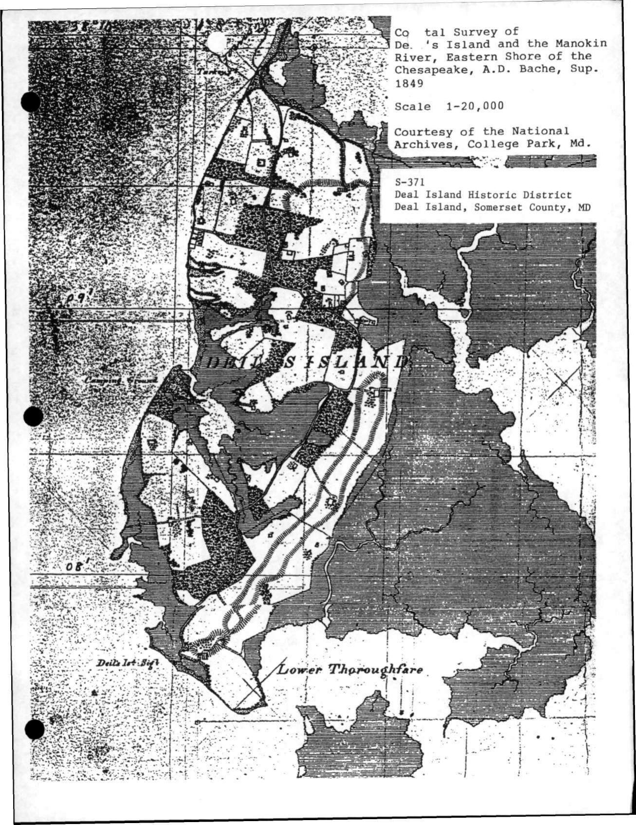
1849: A U.S. Coast Survey map uses "Deil's Island."
19th century: "Deil's" becomes "Deal's," and eventually the modern "Deal Island."
Why "Damned Quarter"?
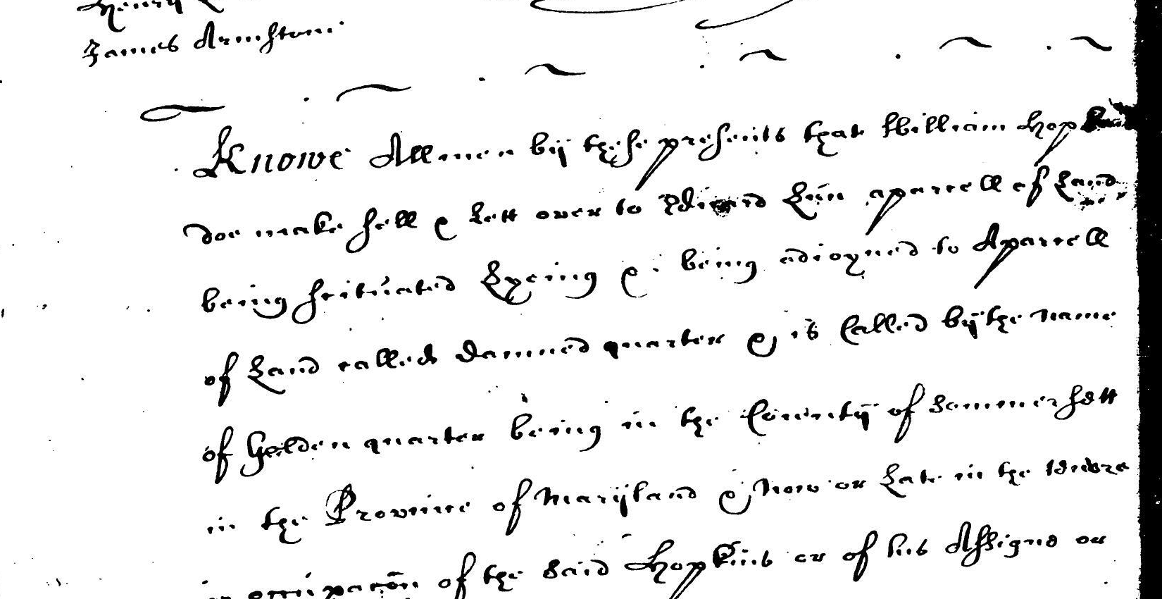
Whatever its origin, Damned Quarter is an extremely old name. On December 26, 1670, a Somerset County judicial record concerning William Hopkins described property adjoining "a parcell of Land called Damned quarter." The land being conveyed was itself called Golden Quarter. That contemporary record proves that Damned Quarter was already an established geographic name within only a few years of Somerset County's creation in 1666.
The pairing of Damned Quarter and Golden Quarter in the same record is tantalizing, but there is no evidence that one was deliberately named as a joke or contrast to the other. What it does show is the wonderfully expressive style of early Chesapeake land naming. Colonial tracts often carried names reflecting hopes, disappointments, family references, jokes, religion, geography, or a settler's opinion of the land.
The mosquito tradition
One long-standing explanation is wonderfully simple: the first settlers found the place miserable.
Genealogist and historian John F. Polk Jr., writing about the seventeenth-century Damned Quarter country, describes a low landscape of woodland, swamp, marsh, and wet ground. He notes the area's formidable warm-weather populations of mosquitoes and deerflies and records a local tradition that both Damned Quarter and nearby Devil's Island received their ominous names because of the insects. Polk presents this as legend rather than as a fact established by a seventeenth-century document.
The explanation is certainly plausible. Early settlers had no screens, air conditioning, modern repellents, or easy escape from the humid marsh environment. Yet plausibility is not proof. No known seventeenth-century writer has been found saying, in effect, "we named it Damned Quarter because of the mosquitoes."
A modern mosquito footnote
The old explanation may sound less fanciful to anyone who has spent an August day in Lower Eastern Shore marsh country. During one family visit to Assateague Island National Seashore, the mosquitoes became so relentless that we retreated into the Visitor Center. A recent visitor had summed up the experience perfectly in the guestbook:
"Mosquitoes. A real Hitchcock scenario."
That twentieth-century complaint cannot tell us what a settler in the 1660s was thinking, of course. But it does make the traditional explanation for Damned Quarter remarkably easy to imagine.
From Damned Quarter to Dames Quarter
The change was not a neat one-time renaming. Instead, surviving records show several forms existing across the eighteenth century: Damned Quarter, Dam Quarter, Damquarter, Damn'd Quarter, and eventually Dames Quarter. Spelling was not standardized, and clerks often wrote a place name as they understood or heard it.
In 1731, Somerset County officials ordered a road laid out to Richard Wallace's marsh "on Dam Quarter" and referred to the "Main road that runs Through Dam Quarter Island." In June 1776, Revolutionary-era correspondence identified William Roberts as living at a place called "damn'd Quarter." The old form was therefore still very much alive in the late colonial period.
Yet the modern form appears surprisingly early. Somerset County's 1783 tax assessment repeatedly uses "Dames Quarter" for property in the same locality. By the nineteenth century, Dames' Quarter was an established governmental form, and the apostrophe eventually disappeared as well.
No formal act declaring that Damned Quarter had been renamed Dames Quarter has been identified. The evidence looks much more like a gradual transition in spelling and usage. A preference for the more genteel-sounding form may have helped it win out, but that motive should not be stated as fact without evidence.
It is also worth resisting an attractive bit of symmetry. Methodism played an important role in the transformation of Devil's Island into Deal Island, but there is no comparable evidence that Methodists deliberately changed Damned Quarter to Dames Quarter.
Why "Devil's Island"?
Devil's Island is equally old, and perhaps even more mysterious. A Somerset County land transaction dated June 2, 1677 described property on an island "formerly called Devill's Island" between the mouths of the Manokin and Wicomico rivers. The word formerly matters: by 1677, the writer was already treating Devil's Island as an earlier name.
That chronology immediately rules out one popular idea. Revolutionary War pirates, Tory raiders, and smugglers did not create the name. Whatever gave Devil's Island its name happened much earlier.
Three surviving explanations
1. Mosquitoes and harsh living conditions. Polk records the same insect tradition for Devil's Island that he records for Damned Quarter. Given the low, marsh-bound environment, this is quite plausible, but no contemporary naming statement has been found.
2. Survivors of a seventeenth-century shipwreck. A 1990 Washington Post feature stated that survivors of a seventeenth-century wreck first called the place Devil's Island. The article did not identify the wreck or cite a colonial source for the story. The timing is possible, but without earlier documentation it is best treated as another tradition.
3. A European name connected with Indigenous sacred ceremonies. A Maryland Historical Trust National Register nomination preserving Nause-Waiwash oral history associates the old name with Native sacred ceremonies held there. The document uses the historical Christian expression "Devil's worship" to describe those ceremonies. That phrase should be understood as a European Christian characterization of Indigenous religion, not as the Native community's own description of its beliefs. This is an important oral tradition, but it has not been independently confirmed by a seventeenth-century source.
How the Devil Became Deal
Here the documentary trail is stronger. During the late eighteenth century, Methodism took deep root in the island communities of Somerset County. Methodist evangelist Freeborn Garrettson visited the island in 1781 and found an organized Methodist society already established there.
The Maryland Historical Trust's National Register documentation for the Deal Island Historic District credits strong Methodist sentiment with an early alteration of the old name: the v was dropped from Devil's, producing Deil's Island. The older form did not vanish at once. Both old and new spellings continued to appear in early nineteenth-century records and maps.
The intermediate spelling is not merely a later story. An 1849 U.S. Coast Survey was titled Deil's Island and Manokin River, Eastern Shore of Chesapeake. Over time, Deil's became Deal's, and eventually Deal Island.
A Methodist explanation from the nineteenth century
Methodist minister Adam Wallace later wrote about the island and explained that the spelling Deal's had become established. He also preserved a story about the Rev. D. Dailey, who favored that spelling because he did not wish the island's name to suggest that Satan held a right or property there.
In other words, according to the Methodist tradition, the Devil was not driven from the island all at once. He was edited out of the name, one letter at a time.
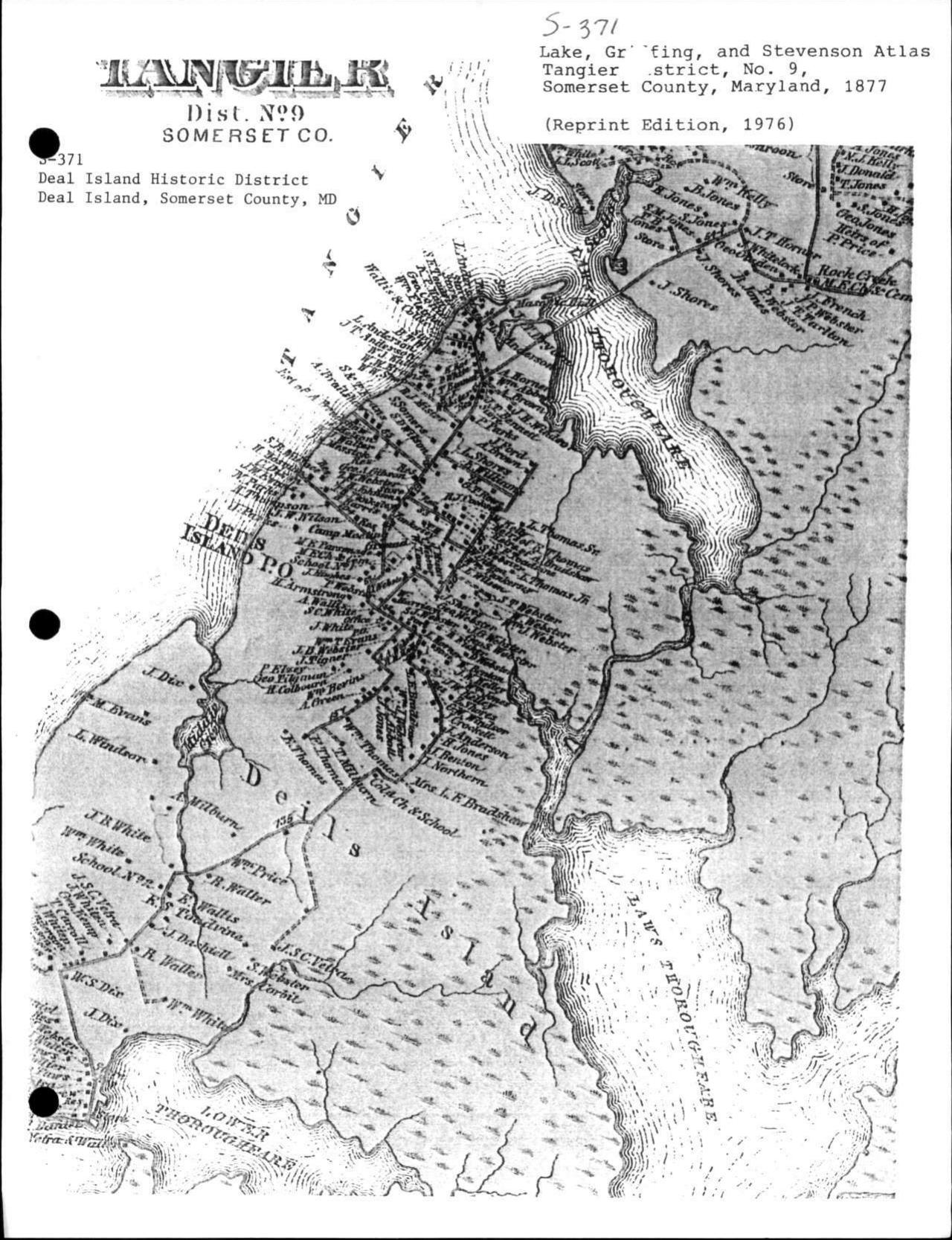
That story also fits the extraordinary religious history of Deal Island. The island became closely associated with the Rev. Joshua Thomas, the famous "Parson of the Islands," and with the growth of Methodism throughout the Lower Eastern Shore. The transition from Devil's to Deil's to Deal's therefore occurred in a community where the Devil's presence in a place name would have carried more than casual significance.
Tories, Raiders, and a Reputation the Names Already Had
Damned Quarter and Devil's Island later acquired exactly the sort of Revolutionary-era history that seems made to explain such names. Isolated creeks, marshes, and islands along the lower Chesapeake offered shelter to raiders, smugglers, and Loyalists. Contemporary accounts describe British and Tory activity around the western Somerset communities.
In June 1776, Somerset County's Committee of Observation reported that William Roberts of "damn'd Quarter" had been carried away during an enemy raid. In 1780, Joseph Dashiell reported that raiders moving up the Nanticoke had proceeded to Damquarter and were welcomed by sympathetic local residents. Maryland Historical Trust research also notes that residents of Devil's Island, Dames Quarter, and neighboring islands sometimes offered refuge to Tory raiders.
These episodes almost certainly strengthened the sinister flavor of the old place names in later memory. They cannot, however, explain their origin. Damned Quarter and Devil's Island had already been named for more than a century.
A Pair of Names Too Good for Travelers to Forget
By 1850 the two old names were already being remembered together. Writer Charles Lanman, in Haw-Ho-Noo; or, Records of a Tourist, noted the earlier names Devil's Island and Damned Quarter while traveling in the Chesapeake country.
Lanman repeated a local joke about a Connecticut skipper unfamiliar with the region. After asking the name of one place and hearing "Devil's Island," the sailor later asked about another and was told "Damned Quarter." According to the story, that was enough Somerset County geography for him; he turned around and headed back down the Bay.
Whether the incident ever happened is beside the point. By the middle of the nineteenth century, people already recognized the names as an irresistible matched pair from an older Somerset County.
What the Old Names Preserve
The two place-name histories are similar without being identical. Damned Quarter became Dames Quarter gradually, through overlapping spellings and usage already visible by the late eighteenth century. No documented formal renaming has been found.
Devil's Island became Deal Island through a more traceable sequence: Devil's, Deil's, Deal's, and finally Deal Island. Nineteenth-century Methodist tradition explicitly connected that change with a desire to remove the Devil's claim from the island's name.
The origins of the old names remain less certain than their later transformations. Mosquitoes and brutal marsh conditions are a long-standing and geographically convincing explanation, especially for Damned Quarter, but they remain tradition rather than documentary proof. The same caution applies to the shipwreck and Indigenous- ceremony traditions surrounding Devil's Island.
Place names are small historical fossils. They preserve how generations understood a landscape, even after the reasons behind the words have been partly forgotten. In western Somerset County, two of the most memorable survived in softened form: Damned Quarter became Dames Quarter, and Devil's Island became Deal Island.
Sources and Further Reading
- Maryland State Archives, Archives of Maryland, Somerset County judicial record, December 26, 1670, p. 59: William Hopkins / Damned Quarter and Golden Quarter record.
- Maryland State Archives, Somerset County judicial proceedings, 1731, road record referring to "Dam Quarter" and "Dam Quarter Island": Archives of Maryland transcription.
- Maryland State Archives, Somerset County 1783 Tax Assessment, including repeated references to "Dames Quarter": 1783 Somerset assessment.
- Maryland Historical Trust, Deal Island Historic District, National Register of Historic Places nomination, S-371: National Register documentation.
- John F. Polk Jr., introduction to Beyond Damned Quarter: The Polk/Pollock Family of the Chesapeake Eastern Shore in the Colonial Era, reprinted in Pollag, Clan Pollock: PDF reprint.
- Naval Documents of the American Revolution, vol. 5, including the June 1776 Somerset County Committee of Observation correspondence referring to "damn'd Quarter": digitized volume.
- Maryland Historical Trust, National Register documentation preserving Nause-Waiwash oral history concerning Devil's Island: National Register nomination.
- Eugene L. Meyer, "Along the Bay, Way of Life Ebbs," The Washington Post, May 31, 1990, for the shipwreck tradition and a modern description of Deal Island: article.
- Charles Lanman, Haw-Ho-Noo; or, Records of a Tourist (Philadelphia, 1850): Project Gutenberg edition.
Image Credits
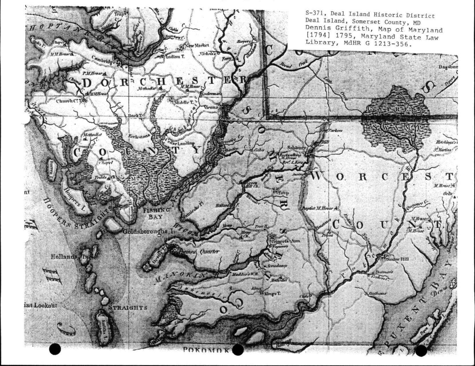
The 1670 manuscript excerpt is from the Maryland State Archives. The 1795 Griffith map excerpt, 1849 U.S. Coast Survey image, and 1877 Tangier District atlas image are reproduced from historical materials included in the Maryland Historical Trust's Deal Island Historic District National Register documentation. Images are presented here for historical and educational reference.